
Сделать пожертвование
Топографическая карта Wausau
Нажмите на карту, чтобы отобразить высоту.
Сделать пожертвование
Wausau
According to the United States Census Bureau, the city has a total area of 20.33 square miles (52.7 km2), of which 19.22 square miles (49.8 km2) is land and 1.11 square miles (2.9 km2) is water. The city is located at an altitude of 1,195 feet (364 m). Wausau is close to the center of the northern half of the Western Hemisphere. Just west of Wausau, 45°N meets 90°W (45°N 90°W / 45°N 90°W / 45; -90), which is exactly halfway between the equator and the north pole and a quarter of the way around the world from the prime meridian.
Сделать пожертвование
Об этой карте
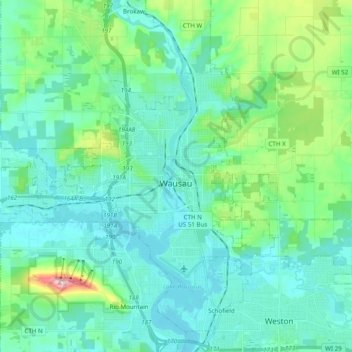
Название: Топографическая карта Wausau, высота, рельеф.
Местонахождение: Wausau, Marathon County, Wisconsin, United States (44.91855 -89.76793 45.00644 -89.57292)
Средняя высота: 394 м
Минимальная высота: 351 м
Максимальная высота: 585 м
Сделать пожертвование
Другие топографические карты
Нажмите на карту, чтобы просмотреть ее топографию, ее высоту и ее рельеф.
George W Mead State Wildlife Management Area
United States > Wisconsin > Marathon County > Town of Bergen
Средняя высота: 343 м
Сделать пожертвование
Bypass Channel Wisconsin River
United States > Wisconsin > Marathon County > Wausau
Средняя высота: 371 м