
Сделать пожертвование
Топографическая карта Barren Springs
Нажмите на карту, чтобы отобразить высоту.
Сделать пожертвование
Об этой карте
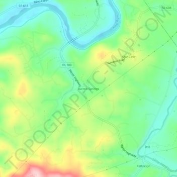
Название: Топографическая карта Barren Springs, высота, рельеф.
Местонахождение: Barren Springs, Wythe County, Virginia, 24313, United States (36.88818 -80.82063 36.92818 -80.78063)
Средняя высота: 642 м
Минимальная высота: 564 м
Максимальная высота: 784 м
Сделать пожертвование
Другие топографические карты
Нажмите на карту, чтобы просмотреть ее топографию, ее высоту и ее рельеф.
Wytheville
United States > Virginia > Wythe County
Wytheville is nestled within the scenic Appalachian Mountains, characterized by a varied topography that features rolling hills, gentle valleys, and steep ridges. The town sits at an elevation of approximately 2,300 feet, which contributes to its cooler climate and offers picturesque views of the surrounding…
Средняя высота: 720 м
Сделать пожертвование
Wytheville
United States > Virginia > Wythe County
Due to its elevation, the climate of Wytheville is either classified as mountain temperate or humid subtropical (Köppen Cfb or Cfa, respectively), and the town straddles the border between USDA Plant Hardiness Zones 6B and 7A. Summers are warm and humid, although significantly cooler than low-elevation places…
Средняя высота: 720 м