
Сделать пожертвование
Топографическая карта Chironico
Нажмите на карту, чтобы отобразить высоту.
Сделать пожертвование
Chironico
The municipality is located in the Leventina district, on the right slope of the mid-Leventina valley at an elevation of 786 meters (2,579 ft). The municipality stretches from the Ticino river at the Biaschina-Schlucht (elevation 450 m (1,480 ft)) up to the Pizzo Campo Tencia (3,072 m (10,079 ft)) in the upper Piumogna valley. The core of the settlement, is made up of the sections of Grumo and Nivo, the latter is the only one in the valley bottom. Above the village center, situated on steeply sloping rock terraces are the settlements of Cala, Doro, Olina, and Osadigo Chiesso. The mountain village of Gribbio has a road connection.
Сделать пожертвование
Об этой карте
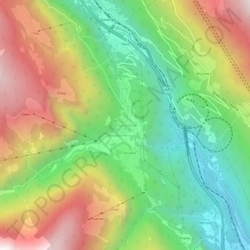
Название: Топографическая карта Chironico, высота, рельеф.
Местонахождение: Chironico, Faido, Circolo di Faido, Distretto di Leventina, Ticino, 6747, Switzerland (46.40327 8.82369 46.44327 8.86369)
Средняя высота: 1 026 м
Минимальная высота: 391 м
Максимальная высота: 1 882 м
Сделать пожертвование
Другие топографические карты
Нажмите на карту, чтобы просмотреть ее топографию, ее высоту и ее рельеф.