
Топографическая карта La Blonderie
Интерактивная карта
Нажмите на карту, чтобы отобразить высоту.
Об этой карте
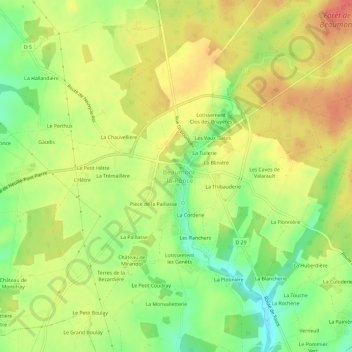
Название: Топографическая карта La Blonderie, высота, рельеф.
Средняя высота: 131 м
Минимальная высота: 97 м
Максимальная высота: 160 м
Другие топографические карты
Нажмите на карту, чтобы просмотреть ее топографию, ее высоту и ее рельеф.
La Mondinerie
France > Centre-Val de Loire > Indre-et-Loire > Beaumont-Louestault > La Mondinerie
La Mondinerie, Beaumont-la-Ronce, Beaumont-Louestault, Chinon, Indre-et-Loire, Centre-Val de Loire, France métropolitaine, 37360, France
Средняя высота: 127 м
La Corderie
France > Centre-Val de Loire > Indre-et-Loire > Beaumont-Louestault
La Corderie, Beaumont-la-Ronce, Beaumont-Louestault, Chinon, Indre-et-Loire, Centre-Val de Loire, France métropolitaine, 37360, France
Средняя высота: 130 м
La Logerie
France > Centre-Val de Loire > Indre-et-Loire > Beaumont-Louestault
La Logerie, Beaumont-la-Ronce, Beaumont-Louestault, Chinon, Indre-et-Loire, Centre-Val de Loire, France métropolitaine, 37360, France
Средняя высота: 118 м
Château de Beaumont
France > Centre-Val de Loire > Indre-et-Loire > Beaumont-Louestault > St-Armel
Château de Beaumont, Rue du 8 Mai 1945, St-Armel, Beaumont-la-Ronce, Beaumont-Louestault, Chinon, Indre-et-Loire, Centre-Val de Loire, France métropolitaine, 37360, France
Средняя высота: 132 м