

Сделать пожертвование
Топографическая карта Cean
Нажмите на карту, чтобы отобразить высоту.
Сделать пожертвование
Об этой карте
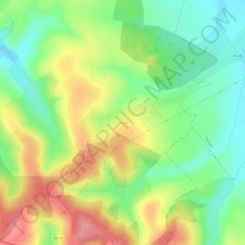
Название: Топографическая карта Cean, высота, рельеф.
Местонахождение: Cean, Săuca, Satu Mare, 447282, Romania (47.42453 22.50060 47.46453 22.54060)
Средняя высота: 186 м
Минимальная высота: 142 м
Максимальная высота: 241 м
Сделать пожертвование
Другие топографические карты
Нажмите на карту, чтобы просмотреть ее топографию, ее высоту и ее рельеф.
Satu Mare
Satu Mare is situated in Satu Mare County, in northwest Romania, on the river Someș, 13 km (8.1 mi) from the border with Hungary and 27 km (17 mi) from the border with Ukraine. The city is located at an altitude of 126 m (413 ft) on the Lower Someș alluvial plain, spreading out from the Administrative Palace…
Средняя высота: 124 м

Satu Mare
Satu Mare is situated in Satu Mare County, in northwest Romania, on the river Someș, 13 km (8.1 mi) from the border with Hungary and 27 km (17 mi) from the border with Ukraine. The city is located at an altitude of 126 m (413 ft) on the Lower Someș alluvial plain, spreading out from the Administrative Palace…
Средняя высота: 124 м

Сделать пожертвование


Сделать пожертвование

Satu Mare
Satu Mare is situated in Satu Mare County, in northwest Romania, on the river Someș, 13 km (8.1 mi) from the border with Hungary and 27 km (17 mi) from the border with Ukraine. The city is located at an altitude of 126 m (413 ft) on the Lower Someș alluvial plain, spreading out from the Administrative Palace…
Средняя высота: 124 м

Tarna Mare
Tarna Mare is situated in the Țara Oașului ethnocultural and historical region in the extreme north of Satu Mare County. It lies at an altitude of 168 m (551 ft), on the banks of the river Tarna Mare. The commune is located 54 km (34 mi) northeast of the county seat, Satu Mare, on the border with Ukraine.
Средняя высота: 292 м
Сделать пожертвование