
Топографическая карта Timahoe
Интерактивная карта
Нажмите на карту, чтобы отобразить высоту.
Об этой карте
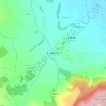
Название: Топографическая карта Timahoe, высота, рельеф.
Местонахождение: Timahoe, The Municipal District of Graiguecullen — Portarlington, County Laois, Leinster, R32 Y09T, Ireland (52.94115 -7.22179 52.98115 -7.18179)
Средняя высота: 146 м
Минимальная высота: 90 м
Максимальная высота: 329 м
Другие топографические карты
Нажмите на карту, чтобы просмотреть ее топографию, ее высоту и ее рельеф.
Stradbally
Stradbally, Stradbally ED, The Municipal District of Graiguecullen — Portarlington, County Laois, Leinster, Ireland
Средняя высота: 92 м
Mountmellick
Mountmellick, The Municipal District of Borris-in-Ossory — Mountmellick, County Laois, Leinster, Ireland
Средняя высота: 76 м
Burke's Cross
Burke's Cross, Lacka ED, The Municipal District of Borris-in-Ossory — Mountmellick, County Laois, Leinster, Ireland
Средняя высота: 195 м
Trumra Rock
Trumra Rock, Trumra ED, The Municipal District of Borris-in-Ossory — Mountmellick, County Laois, Leinster, Ireland
Средняя высота: 105 м
The Municipal District of Portlaoise
The Municipal District of Portlaoise, County Laois, Leinster, Ireland
Средняя высота: 138 м
The Municipal District of Graiguecullen — Portarlington
The Municipal District of Graiguecullen — Portarlington, County Laois, Leinster, Ireland
Средняя высота: 113 м
Killadooley
Killadooley, Ballybrophy ED, The Municipal District of Borris-in-Ossory — Mountmellick, County Laois, Leinster, Ireland
Средняя высота: 122 м