
Сделать пожертвование
Топографическая карта Gstaad
Нажмите на карту, чтобы отобразить высоту.
Сделать пожертвование
Gstaad
Long known for its walking and hiking trails of varying degrees of difficulty, the mountain air and ambiance attract guests year-round from around the world. Gstaad is also known for its ski and cross-country slopes and winter hiking trails. Glacier 3000 is a major attraction, offering guaranteed snow from December to March and unique high-altitude experiences, including the world’s first summit-to-summit suspension footbridge with views of the Matterhorn and Mont Blanc. Gstaad also offers distinctive culinary experiences, such as the ‘Fondueland Gstaad,’ where visitors can enjoy fondue in oversized outdoor caquelon pots set amidst scenic Alpine landscapes. To facilitate this, fondue backpacks contain all the necessary ingredients and equipment that can be rented from local dairies, allowing for a dining experience in nature.
Сделать пожертвование
Об этой карте
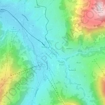
Название: Топографическая карта Gstaad, высота, рельеф.
Местонахождение: Gstaad, Saanen, Obersimmental-Saanen administrative district, Oberland administrative region, Bern, 3780, Switzerland (46.45216 7.26875 46.49216 7.30875)
Средняя высота: 1 245 м
Минимальная высота: 1 010 м
Максимальная высота: 1 922 м
Сделать пожертвование
Другие топографические карты
Нажмите на карту, чтобы просмотреть ее топографию, ее высоту и ее рельеф.
Boltigen
Switzerland > Bern > Obersimmental-Saanen administrative district
The municipality includes the cooperative farms (Bäuerten) of Boltigen, Adlemsried, Eschi, Oberbäuert (which includes Littisbach and Unterbächen), Reidenbach, Schwarzenmatt, Simmenegg and Weissenbach. The area includes the valley floor around the Simme River, both sides of the valley and the surrounding…
Средняя высота: 1 459 м