
Сделать пожертвование
Топографическая карта Dahong
Нажмите на карту, чтобы отобразить высоту.
Сделать пожертвование
Об этой карте
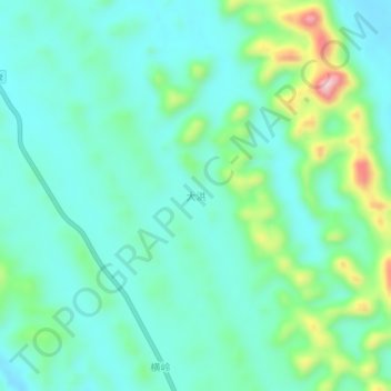
Название: Топографическая карта Dahong, высота, рельеф.
Местонахождение: Dahong, Guangxi, China (23.71360 108.65500 23.75360 108.69500)
Средняя высота: 228 м
Минимальная высота: 162 м
Максимальная высота: 449 м
Сделать пожертвование
Другие топографические карты
Нажмите на карту, чтобы просмотреть ее топографию, ее высоту и ее рельеф.
Guilin
Guilin (Standard Zhuang: Gveilinz), formerly romanized as Kweilin, is a prefecture-level city in the northeast of China's Guangxi Zhuang Autonomous Region. It is situated on the west bank of the Li River and borders Hunan to the north. Its name means "forest of sweet osmanthus", owing to the large number of…
Средняя высота: 472 м
Сделать пожертвование
Сделать пожертвование
Сделать пожертвование
Сделать пожертвование
Сделать пожертвование
Baise
Baise has a monsoon-influenced, humid subtropical climate (Köppen Cwa), with short, mild, and dry winters, and long, very hot and humid summers. The monthly 24-hour average temperature ranges from 13.5 °C (56.3 °F) in January to 28.4 °C (83.1 °F) in July, for an annual mean of 22.12 °C (71.8 °F).…
Средняя высота: 688 м
Сделать пожертвование
Сделать пожертвование
Guilin
Guilin (Standard Zhuang: Gveilinz; alternatively romanized as Kweilin) is a prefecture-level city in the northeast of China's Guangxi Zhuang Autonomous Region. It is situated on the west bank of the Li River and borders Hunan to the north. Its name means "forest of sweet osmanthus", owing to the large number…
Средняя высота: 477 м
Сделать пожертвование
Сделать пожертвование
Сделать пожертвование
Сделать пожертвование
Yongfu County
Yongfu County (Chinese: 永福县; pinyin: Yǒngfú Xiàn) is a county under the administration of the prefecture-level city of Guilin, Guangxi, China, located 55 km (34 mi) to the southwest of downtown Guilin. The county is mostly rural and hilly, marked by the same dramatic karst topography for which Guilin is famous.
Средняя высота: 344 м
Guilin
Guilin (Standard Zhuang: Gveilinz; alternatively romanized as Kweilin) is a prefecture-level city in the northeast of China's Guangxi Zhuang Autonomous Region. It is situated on the west bank of the Li River and borders Hunan to the north. Its name means "forest of sweet osmanthus", owing to the large number…
Средняя высота: 477 м