
Сделать пожертвование
Топографическая карта Ponmudi
Нажмите на карту, чтобы отобразить высоту.
Сделать пожертвование
Ponmudi
Ponmudi (the Golden Peak) is a hill station in the Peringamala gramapanchayath of Trivandrum District of Kerala in India. It is located 22km west of Vithura town, 53 km north-east of Trivandrum City, 78 km south-east of Varkala town and 69 km north-east of Kovalam Beach at an altitude of 1,100 m (3,600 ft). Ponmudi (Varayadumotta) peak is a part of the Western Ghats mountain range that runs parallel to the Arabian Sea. Ponmudi is a popular honeymoon destination in South India. The normal temperature of Ponmudi is between 18 and 25 °C (64 and 77 °F).
Сделать пожертвование
Об этой карте
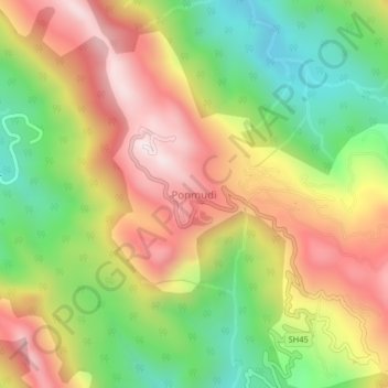
Название: Топографическая карта Ponmudi, высота, рельеф.
Местонахождение: Ponmudi, Nedumangad, Thiruvananthapuram, Kerala, India (8.74000 77.09500 8.78000 77.13500)
Средняя высота: 673 м
Минимальная высота: 290 м
Максимальная высота: 1 071 м
Сделать пожертвование
Другие топографические карты
Нажмите на карту, чтобы просмотреть ее топографию, ее высоту и ее рельеф.