
Сделать пожертвование
Топографическая карта Peechi
Нажмите на карту, чтобы отобразить высоту.
Сделать пожертвование
Об этой карте
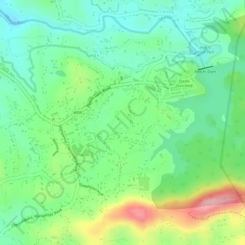
Название: Топографическая карта Peechi, высота, рельеф.
Местонахождение: Peechi, Thrissur, Kerala, 680653, India (10.51292 76.35067 10.53490 76.37002)
Средняя высота: 89 м
Минимальная высота: 21 м
Максимальная высота: 208 м
Сделать пожертвование
Другие топографические карты
Нажмите на карту, чтобы просмотреть ее топографию, ее высоту и ее рельеф.
Thrissur
Thrissur is the headquarters of Thrissur district, in the centre of the Indian state of Kerala. The city is 75 km north-east of Kochi, 133 km south-west of Coimbatore, 124 km south-east of Kozhikode and 151 km north of Changanacherry. The city is located in a hillock called Thekkinkadu Maidan which is the…
Средняя высота: 36 м
Kulam -Balakrishnan,Karamangattil, Chazhoor, Chetakulam
India > Kerala > Thrissur > Puthenpeedika
Средняя высота: 6 м
Сделать пожертвование
Сделать пожертвование
Thrissur
Thrissur is the headquarters of Thrissur district, in the center of the Indian state of Kerala. The city is 75 km north-east of Kochi, 133 km south-west of Coimbatore, 124 km south-east of Kozhikode and 151 km north of Changanacherry. The city is located in a hillock called Thekkinkadu Maidan which is the…
Средняя высота: 36 м
Сделать пожертвование
Thrissur
Thrissur is the headquarters of Thrissur district, in the centre of the Indian state of Kerala. The city is 75 km north-east of Kochi, 133 km south-west of Coimbatore, 124 km south-east of Kozhikode and 151 km north of Changanacherry. The city is located in a hillock called Thekkinkadu Maidan which is the…
Средняя высота: 36 м