
Сделать пожертвование
Топографическая карта Neulassing
Нажмите на карту, чтобы отобразить высоту.
Сделать пожертвование
Об этой карте
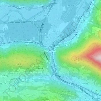
Название: Топографическая карта Neulassing, высота, рельеф.
Местонахождение: Neulassing, Selzthal, Bezirk Liezen, Styria, 8900, Austria (47.52594 14.28554 47.56594 14.32554)
Средняя высота: 748 м
Минимальная высота: 620 м
Максимальная высота: 1 360 м
Сделать пожертвование
Другие топографические карты
Нажмите на карту, чтобы просмотреть ее топографию, ее высоту и ее рельеф.
Сделать пожертвование
Grundlsee
Austria > Styria > Bezirk Liezen
The climate in Grundlsee is determined by its geographical location in the Aussee Basin. It is characterized mainly by the high altitude and the location in the northern congestion area. The result is, in the case of flow conditions from the west to the north, often days of precipitation, which in winter are…
Средняя высота: 1 240 м
Ramsau am Dachstein
Austria > Styria > Bezirk Liezen
Ramsau am Dachstein is situated between the Dachstein range of mountains in the north and the Enns valley in the south. While the Dachstein range contains peaks up to 2,995 m (9,826 ft) and the towns of the Enns valley, such as Schladming, lie at around 700 m (2,300 ft) above sea level, the Ramsau plateau is a…
Средняя высота: 1 526 м
Сделать пожертвование
Сделать пожертвование