

Топографическая карта Coatbridge
Нажмите на карту, чтобы отобразить высоту.
Coatbridge
The topography of Coatbridge was an important feature in the town's development during the Industrial Revolution. Coatbridge rests 60 metres below the "Slamannan plateau" and neighbouring Airdrie sits on its edge. The low-lying flat ground of Coatbridge was a vital factor in the siting of the town's blast furnaces and the Monkland Canal route. Although Airdrie was an already established town and had local supplies of ironstone, the Monkland Canal link did not extend into Airdrie because of its higher elevation. The Clyde Valley plan of 1949 described Coatbridge as 'situated over a flooded coalfield'. Tenement buildings in Coatbridge were not built to the same level as Glasgow tenements due to danger of local subsidence from centuries of local mining.
Об этой карте
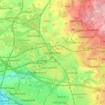
Название: Топографическая карта Coatbridge, высота, рельеф.
Местонахождение: Coatbridge, North Lanarkshire, Scotland, ML5 3HJ, United Kingdom (55.82249 -4.06599 55.90249 -3.98599)
Средняя высота: 100 м
Минимальная высота: 14 м
Максимальная высота: 214 м
Другие топографические карты
Нажмите на карту, чтобы просмотреть ее топографию, ее высоту и ее рельеф.


Cumbernauld
United Kingdom > Scotland > North Lanarkshire
Cumbernauld's name probably comes from the Gaelic comar nan allt, meaning "meeting of the burns or streams". There are differing views as to the etymology of this. One theory is that from its high point in the Central Belt, its streams flow both west to the River Clyde and east to the Firth of Forth so…
Средняя высота: 113 м
Cumbernauld
United Kingdom > Scotland > North Lanarkshire
Cumbernauld's name probably comes from the Gaelic comar nan allt, meaning "meeting of the burns or streams". There are differing views as to the etymology of this. One theory is that from its high point in the Central Belt, its streams flow both west to the River Clyde and east to the Firth of Forth so…
Средняя высота: 113 м
Cumbernauld
United Kingdom > Scotland > North Lanarkshire
Cumbernauld's name probably comes from the Gaelic comar nan allt, meaning "meeting of the burns or streams". There are differing views as to the etymology of this. One theory is that from its high point in the Central Belt, its streams flow both west to the River Clyde and east to the Firth of Forth so…
Средняя высота: 113 м