
Топографическая карта Village of Mamaroneck
Интерактивная карта
Нажмите на карту, чтобы отобразить высоту.
Об этой карте
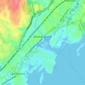
Название: Топографическая карта Village of Mamaroneck, высота, рельеф.
Местонахождение: Village of Mamaroneck, Town of Mamaroneck, Westchester County, New York, 10543, United States (40.92154 -73.74992 40.96938 -73.71373)
Средняя высота: 15 м
Минимальная высота: -3 м
Максимальная высота: 65 м
Other areas of the town include Heathcote Hill, overlooking the harbor, Harbor Heights (the heights) to the northeast, Old Rye Neck (settled in the 1880s), Rye Neck (settled in the 1920s and 1930s), Orienta, and Washingtonville, better known as "The Flats", due to the flat, low-lying topography of the area.
Другие топографические карты
Нажмите на карту, чтобы просмотреть ее топографию, ее высоту и ее рельеф.
Village of Larchmont
United States > New York > Westchester County > Town of Mamaroneck
Village of Larchmont, Town of Mamaroneck, Westchester County, New York, 10538, United States
Средняя высота: 8 м