
Сделать пожертвование
Топографическая карта Vienna
Нажмите на карту, чтобы отобразить высоту.
Сделать пожертвование
Vienna
Vienna is located in northeastern Austria, at the easternmost extension of the Alps in the Vienna Basin. The earliest settlement, at the location of today's inner city, was south of the meandering Danube while the city now spans both sides of the river. Elevation ranges from 151 to 542 m (495 to 1,778 ft). The city has a total area of 414.65 square kilometers (160.1 sq mi), making it the largest city in Austria by area.
Сделать пожертвование
Об этой карте
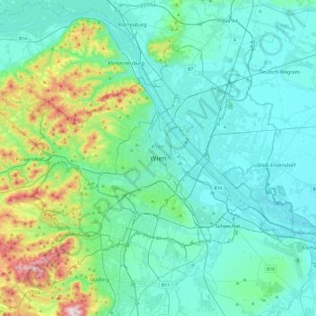
Название: Топографическая карта Vienna, высота, рельеф.
Местонахождение: Vienna, 1010, Austria (48.04835 16.21250 48.36835 16.53250)
Средняя высота: 231 м
Минимальная высота: 145 м
Максимальная высота: 650 м
Сделать пожертвование
Другие топографические карты
Нажмите на карту, чтобы просмотреть ее топографию, ее высоту и ее рельеф.
Vienna
Vienna is located in northeastern Austria, at the easternmost extension of the Alps in the Vienna Basin. The earliest settlement, at the location of today's inner city, was south of the meandering Danube while the city now spans both sides of the river. Elevation ranges from 151 to 542 m (495 to 1,778 ft). The…
Средняя высота: 227 м
Сделать пожертвование
Vienna
Vienna is located in northeastern Austria, at the easternmost extension of the Alps in the Vienna Basin. The earliest settlement, at the location of today's inner city, was south of the meandering Danube, while the city now spans both sides of the river. Elevation ranges from 151 to 542 m (495 to 1,778 ft).…
Средняя высота: 227 м
Сделать пожертвование
Zell am See
Austria > Salzburg > Bezirk Zell am See
Zell am See provides winter skiing on the above Schmittenhöhe mountain. The skiable area is approximately 138 km, including the pistes on the Kitzsteinhorn and Kaprun Maiskogel. The ski pass covers the whole area including transport to and from the glacier which is open most of the year, dependent on…
Средняя высота: 1 118 м
Сделать пожертвование
Сделать пожертвование
Graz
Graz is situated on both sides of the river Mur in southeast Austria. It is about 150 km (93 mi) southwest of Vienna (Wien). The nearest larger urban centre is Maribor (Marburg) in Slovenia, which is about 50 km (31 mi) to the south. Graz is the capital of Styria and the largest city in the federal state, a…
Средняя высота: 426 м
Сделать пожертвование
Vienna
Vienna is located in northeastern Austria, at the easternmost extension of the Alps in the Vienna Basin. The earliest settlement, at the location of today's inner city, was south of the meandering Danube, while the city now spans both sides of the river. Elevation ranges from 151 to 542 m (495 to 1,778 ft).…
Средняя высота: 227 м
Schneeberg
Austria > Lower Austria > Bezirk Neunkirchen > Schwarzau im Gebirge
A rack-and-pinion railway, the Schneeberg Railway, now over 100 years old, climbs to a height of 1,800 m (5,900 ft), reducing the walk to the summit to an hour or two. There are also a number of other routes for walkers, including from the spa resort of Puchberg am Schneeberg to the east, or from the south, in…
Средняя высота: 1 081 м
Сделать пожертвование
Сделать пожертвование
Сделать пожертвование
Hallstatt
Austria > Upper Austria > Bezirk Gmunden
The Hallstatt salt mine is the world's oldest working salt mine. The mine is located within the Upper Permian to Lower Triassic Haselgebirge Formation of the Northern Limestone Alps. The Hallstatt salt mine comprises 21 levels and several smaller shafts ranging from 514 metres (1,686 ft) above sea level…
Средняя высота: 1 514 м
Сделать пожертвование
Сделать пожертвование
Graz
Graz is situated on both sides of the Mur river in southeast Austria. It is about 150 km (93 mi) southwest of Vienna (Wien). The nearest larger urban centre is Maribor (Marburg) in Slovenia, which is about 50 km (31 mi) to the south. Graz is the state capital and largest city in Styria, a green and heavily…
Средняя высота: 426 м
Сделать пожертвование
Сделать пожертвование
Kaprun
Austria > Salzburg > Bezirk Zell am See
Kaprun (German pronunciation: [kaˈpruːn]) is a municipality in the Zell am See District in the province of Salzburg in Austria. Together with the neighboring city of Zell am See the town presents itself as the tourist destination and skiing area "Zell am See-Kaprun". Kaprun distinguishes itself from its…
Средняя высота: 1 819 м
Сделать пожертвование
Vienna
Vienna is located in northeastern Austria, at the easternmost extension of the Alps in the Vienna Basin. The earliest settlement, at the location of today's inner city, was south of the meandering Danube, while the city now spans both sides of the river. Elevation ranges from 151 to 542 m (495 to 1,778 ft).…
Средняя высота: 227 м
Sankt Sigmund im Sellrain
Austria > Tyrol > Bezirk Innsbruck-Land
Sankt Sigmund im Sellrain is a municipality in western Austria, in the district of Innsbruck-Land in the state of Tyrol located 23.3 kilometres (14.5 mi) southeast of Innsbruck, in the deepest part of the Sellrain Valley. It has a large area and the highest elevation. The main source of income is winter…
Средняя высота: 2 289 м
Сделать пожертвование
Ischgl
Austria > Tyrol > Bezirk Landeck
Ischgl has a weather station at an altitude of 2,327 m (7,635 ft). This weather station is located within the alpine climate zone (Köppen ETH), closely bordering on a subarctic climate (Köppen Dfc), because the hottest month is only 9.9 °C (49.8 °F).
Средняя высота: 2 251 м
Сделать пожертвование
Brandnertal
Austria > Vorarlberg > Bezirk Bludenz > Brand
The Brandnertal is located in the southern part of Vorarlberg, in the far west of Austria. Adjacent to Switzerland, the Principality of Liechtenstein and Germany. In the immediate vicinity of the city of Bludenz starts the Brandnertal. From Bürs the valley rises, via Bürserberg to Brand, which is at an…
Средняя высота: 1 572 м
Сделать пожертвование
Wachau Cultural Landscape
Austria > Lower Austria > Bezirk Krems
The Danube valley in Austria between the cities of Melk and Krems in Lower Austria is called the Wachau. This stretch of the valley includes the hills and the adjacent Dunkelsteiner Wald (Dunkelsteiner Forest) and the southern Waldviertel. The Danube river flows north-northeast from Melk to Dürnstein through…
Средняя высота: 486 м
Сделать пожертвование
Zell am See
Austria > Salzburg > Bezirk Zell am See
Zell am See provides winter skiing on the above Schmittenhöhe mountain. The skiable area is around 138 km, including the pistes on the Kitzsteinhorn and Kaprun Maiskogel. The ski pass covers the whole area including transport to and from the glacier, which is open most of the year, dependent on snowfall. Zell…
Средняя высота: 1 118 м
Hallstatt
Austria > Upper Austria > Bezirk Gmunden
The Hallstatt salt mine is the world's oldest working salt mine. The mine is located within the Upper Permian to Lower Triassic Haselgebirge Formation of the Northern Limestone Alps. The Hallstatt salt mine comprises 21 levels and several smaller shafts ranging from 514 m above sea level (Erbstollen level) to…
Средняя высота: 1 514 м
Сделать пожертвование
Pasterze
Austria > Carinthia > Bezirk Spittal an der Drau > Heiligenblut am Großglockner
Средняя высота: 2 599 м
Sölden
Austria > Tyrol > Bezirk Imst
The main village of Sölden is at an elevation of 1,368 metres (4,488 ft) above sea level, and the upper village of Hochsölden at 2,090 m (6,857 ft) has 5 four-star hotels. The highest peak is the Wildspitze, at 3,768 m (12,362 ft), the second highest mountain in Austria, after the Großglockner.
Средняя высота: 2 483 м
Сделать пожертвование
Fischbach
Austria > Styria > Bezirk Weiz
Fischbach is a town in the Fischbacher Alpen and is located about 12 km (7.5 mi) northwest of Birkfeld and about 27 km (17 mi) air-line distance from the district capital Weiz. The maximum north-south extension as well as the maximum east-west extension are each about nine kilometers (5.6 mi). The municipality…
Средняя высота: 1 024 м
Fürstenfeld
Austria > Styria > Bezirk Hartberg-Fürstenfeld
Fürstenfeld is located in the lower Feistritz [ceb; de; sh; sv] valley near the Burgenland border. Elevation of the urban area ranges from 255m to approximately 300 m ü. A. The city`s central part sits on a river terrace two dozen meters above the valley floor.
Средняя высота: 283 м
Сделать пожертвование
Сделать пожертвование
Burgenland
The province has a long history of Slavic, as well Austrian-German and Hungarian-Magyar settlement. The province's easternmost portion (the shores of the Neusiedler See) carried its own topographical term Seewinkel in Austrian-German. This is the area least influenced by Austrian-German since the Hungarian and…
Средняя высота: 373 м
Millstatt am See
Austria > Carinthia > Bezirk Spittal an der Drau
It is situated on the southern slope of the Gurktal Alps (Nock Mountains), on an alluvial fan peninsula on the lake's northern shore. The municipal area reaches from an elevation of 588 m (1,929 ft) at the lakeside to 2,101 m (6,893 ft) AA at the crest of the Millstätter Alpe massif. It comprises the…
Средняя высота: 1 149 м
Сделать пожертвование
Сделать пожертвование
Сделать пожертвование
Сделать пожертвование