
Топографическая карта Nubra
Интерактивная карта
Нажмите на карту, чтобы отобразить высоту.
Об этой карте
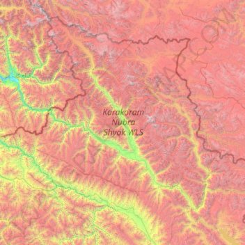
Название: Топографическая карта Nubra, высота, рельеф.
Местонахождение: Nubra, Leh district, Ladakh, 194401, India (33.97611 76.66317 35.67455 79.04537)
Средняя высота: 4 978 м
Минимальная высота: 2 471 м
Максимальная высота: 7 793 м
The main road access to Nubra is over Khardung La pass which is open throughout the year. The highest elevation of Khardung La is 5,359 m (17,582 ft), its status as the highest motorable road in the world is no longer accepted by most authorities. An alternative route, opened in 2008, crosses the Wari La from Sakti, to the east of Khardung La, connecting to the main Nubra road system via Agham and Khalsar along the Shyok River. There are also trekkable passes over the Ladakh Range from the Indus Valley at various points. Routes from Nubra to Baltistan and Yarkand, though historically important, have been closed since 1947 and 1950 respectively.
Другие топографические карты
Нажмите на карту, чтобы просмотреть ее топографию, ее высоту и ее рельеф.
Karakoram Pass
Karakoram Pass, Nubra, Leh District, Ladakh, India
Средняя высота: 5 521 м
Siachen Glacier
Siachen Glacier, Nubra, Leh district, Ladakh, India
Средняя высота: 5 448 м
Daulat Beg Oldi
Daulat Beg Oldi, Nubra, Leh district, Ladakh, India
Средняя высота: 5 085 м