
Сделать пожертвование
Топографическая карта Seia
Нажмите на карту, чтобы отобразить высоту.
Сделать пожертвование
Seia
The municipality is limited to the north by the municipalities of Nelas and Mangualde, to the northeast by Gouveia, to the east by Manteigas, to the southeast by Covilhã, to the southwest by Arganil and to the west by Oliveira do Hospital. In this municipality is located the highest point in mainland Portugal, Torre, in Serra da Estrela, with 1,993 meters of altitude. The municipality of Seia covers a large part of Serra da Estrela and is also the only one in Portugal where there is a natural ski resort, Vodafone Ski Resort, located within the limits of the parish of Loriga.
Сделать пожертвование
Об этой карте
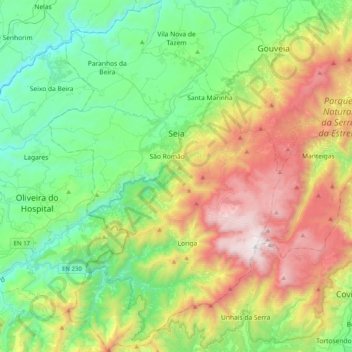
Название: Топографическая карта Seia, высота, рельеф.
Местонахождение: Seia, Guarda, Portugal (40.22992 -7.84923 40.53552 -7.58343)
Средняя высота: 754 м
Минимальная высота: 150 м
Максимальная высота: 1 989 м
Сделать пожертвование
Другие топографические карты
Нажмите на карту, чтобы просмотреть ее топографию, ее высоту и ее рельеф.
Сделать пожертвование
Сделать пожертвование
Сделать пожертвование
Сделать пожертвование
Porto Soito
Portugal > Guarda > Figueiró da Serra e Freixo da Serra > Figueiró da Serra > Porto Soito
Средняя высота: 722 м