
Топографическая карта Springfield
Интерактивная карта
Нажмите на карту, чтобы отобразить высоту.
Об этой карте
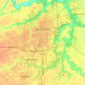
Название: Топографическая карта Springfield, высота, рельеф.
Местонахождение: Springfield, Sangamon County, Illinois, United States (39.65366 -89.77318 39.87417 -89.56851)
Средняя высота: 178 м
Минимальная высота: 152 м
Максимальная высота: 201 м
The city is at an elevation of 558 feet (170 m) above sea level. According to the 2010 census, Springfield has a total area of 65.764 square miles (170.33 km2), of which 59.48 square miles (154.05 km2) (or 90.44%) is land and 6.284 square miles (16.28 km2) (or 9.56%) is water. The city is located in the Lower Illinois River Basin, in a large area known as Till Plain. Sangamon County, and the city of Springfield, are in the Springfield Plain subsection of Till Plain. The Plain is underlain by glacial till that was deposited by a large continental ice sheet that repeatedly covered the area during the Illinoian Stage.
Другие топографические карты
Нажмите на карту, чтобы просмотреть ее топографию, ее высоту и ее рельеф.
Williamsville
United States > Illinois > Sangamon County
Williamsville, Sangamon County, Illinois, 62693, United States
Средняя высота: 177 м
Archer
United States > Illinois > Sangamon County > Springfield
Archer, Springfield, Sangamon County, Illinois, 62711, United States
Средняя высота: 184 м
Spaulding
United States > Illinois > Sangamon County
Spaulding, Sangamon County, Illinois, United States
Средняя высота: 171 м
Pleasant Plains
United States > Illinois > Sangamon County
Pleasant Plains, Sangamon County, Illinois, United States
Средняя высота: 187 м