

Топографическая карта Pendlebury
Нажмите на карту, чтобы отобразить высоту.
Pendlebury
Pendlebury is situated on a ridge overlooking the lower Irwell Valley, almost midway between Manchester and Bolton and is neighboured by Irlams o' th' Height, Pendleton and Clifton. Much of the boundary between Pendlebury and Clifton is defined by Slack Brook which was culverted many years ago after the area was used for landfill. Slack Brook eventually empties into the Irwell a short distance upstream from Agecroft Road Bridge (A6044). The surface of the land slopes generally upwards from southwest (Swinton) to northeast (Irwell Valley), from about 120 feet (40 m) to nearly 300 feet (90 m) above the ordnance datum. However, the topography of the land around Lumn's Lane has changed due to the dumping of mining waste from the former collieries and the area has been used as a landfill site by the Greater Manchester Waste Disposal Authority since 1982, taking ten percent of Greater Manchester's waste each year.
Об этой карте
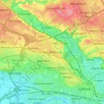
Название: Топографическая карта Pendlebury, высота, рельеф.
Местонахождение: Pendlebury, Salford, Greater Manchester, England, M27 6FF, United Kingdom (53.47616 -2.37071 53.55616 -2.29071)
Средняя высота: 64 м
Минимальная высота: 18 м
Максимальная высота: 138 м
Другие топографические карты
Нажмите на карту, чтобы просмотреть ее топографию, ее высоту и ее рельеф.


