
Сделать пожертвование
Топографическая карта Hood River
Нажмите на карту, чтобы отобразить высоту.
Сделать пожертвование
Hood River
Temperatures for the year as a whole are slightly cooler than in most other low-elevation towns in the region, especially at night because of air drainage off the surrounding mountains.
Сделать пожертвование
Об этой карте
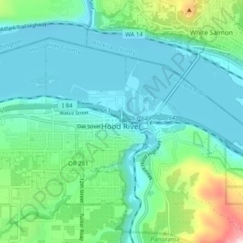
Название: Топографическая карта Hood River, высота, рельеф.
Местонахождение: Hood River, Hood River County, Oregon, United States (45.69298 -121.56508 45.72651 -121.49538)
Средняя высота: 112 м
Минимальная высота: 14 м
Максимальная высота: 504 м
Сделать пожертвование
Другие топографические карты
Нажмите на карту, чтобы просмотреть ее топографию, ее высоту и ее рельеф.
Mount Hood
United States > Oregon > Hood River County
Timberline Lodge is a National Historic Landmark located on the southern flank of Mount Hood just below Palmer Glacier, with an elevation of about 6,000 ft (1,800 m).
Средняя высота: 2 716 м
Mount Hood
United States > Oregon > Hood River County
Mount Hood, also known as Wy'east, is an active stratovolcano in the Cascade Range and is a member of the Cascade Volcanic Arc. It was formed by a subduction zone on the Pacific Coast and rests in the Pacific Northwest region of the United States. It is located about 50 miles (80 km) east-east-southeast of…
Средняя высота: 2 716 м
Mount Hood
United States > Oregon > Hood River County
Timberline Lodge is a National Historic Landmark located on the southern flank of Mount Hood just below Palmer Glacier, with an elevation of about 6,000 ft (1,800 m).
Средняя высота: 2 716 м
Сделать пожертвование