
Сделать пожертвование
Топографическая карта Mysuru
Нажмите на карту, чтобы отобразить высоту.
Сделать пожертвование
Mysuru
Mysore (/maɪˈsɔːr/ (listen)), officially Mysuru ([ˈmaɪˈsuːɾu] (listen)), is a city in the southern part of the state of Karnataka, India. Mysore city is geographically located between 12° 18′ 26″ north latitude and 76° 38′ 59″ east longitude. It is located at an altitude of 770 m (2,530 ft) above mean sea level.
Сделать пожертвование
Об этой карте
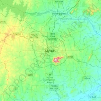
Название: Топографическая карта Mysuru, высота, рельеф.
Местонахождение: Mysuru, Mysuru taluk, Mysuru District, Karnataka, 570001, India (12.14518 76.49536 12.46518 76.81536)
Средняя высота: 727 м
Минимальная высота: 640 м
Максимальная высота: 1 048 м
Сделать пожертвование
Другие топографические карты
Нажмите на карту, чтобы просмотреть ее топографию, ее высоту и ее рельеф.
Mysuru
India > Karnataka > Mysuru taluk > Mysuru
Mysore is situated at the foothills of the Chamundi Hills. At an altitude of 770 m (2,530 ft) above mean sea level, the city of Mysore is geographically located at 12° 18′ 26″ north latitude and 76° 38′ 59″ east longitude. It is about 140 km (87.0 mi) southwest of the state's capital, Bangalore, and…
Средняя высота: 752 м