
Спасибо за поддержку этого сайта ❤️
Сделать пожертвование
Сделать пожертвование
Топографическая карта Brian Head
Нажмите на карту, чтобы отобразить высоту.
Спасибо за поддержку этого сайта ❤️
Сделать пожертвование
Сделать пожертвование
Brian Head
The community, at an elevation of 9,800 feet (3,000 m) above sea level, is the highest town in Utah. It is located on State Route 143 and is east of Interstate 15. Brian Head is approximately three miles north of Cedar Breaks National Monument.
Спасибо за поддержку этого сайта ❤️
Сделать пожертвование
Сделать пожертвование
Об этой карте
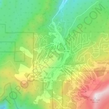
Название: Топографическая карта Brian Head, высота, рельеф.
Местонахождение: Brian Head, Iron County, Utah, 84719, United States (37.67689 -112.86086 37.71835 -112.81505)
Средняя высота: 3 031 м
Минимальная высота: 2 729 м
Максимальная высота: 3 449 м
Спасибо за поддержку этого сайта ❤️
Сделать пожертвование
Сделать пожертвование
Другие топографические карты
Нажмите на карту, чтобы просмотреть ее топографию, ее высоту и ее рельеф.