
Сделать пожертвование
Топографическая карта Lake Point
Нажмите на карту, чтобы отобразить высоту.
Сделать пожертвование
Lake Point
John C. Frémont, a second lieutenant in the U.S. Army Corps of Topographical Engineers, was commissioned by the US Government to explore the Mexican territory west of the Louisiana Purchase with a special interest in the terrain and various routes that could link the Midwest to California. In the summer of 1843 Fremont took a smaller team from his men and veered off the Oregon Trail at Fort Hall to the Bear River into its terminus at the Great Salt Lake. He explored the lake on an eighteen-foot inflatable rubber boat loaded with provisions and produced a map of the lake and its surroundings.
Сделать пожертвование
Об этой карте
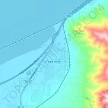
Название: Топографическая карта Lake Point, высота, рельеф.
Местонахождение: Lake Point, Tooele County, Utah, United States (40.65275 -112.29075 40.71823 -112.22836)
Средняя высота: 1 425 м
Минимальная высота: 1 280 м
Максимальная высота: 2 329 м
Сделать пожертвование
Другие топографические карты
Нажмите на карту, чтобы просмотреть ее топографию, ее высоту и ее рельеф.
Deseret Peak
United States > Utah > Tooele County
Deseret Peak is the highest peak in the Stansbury Mountains with an elevation of 11,035 ft. It is located in the Deseret Peak Wilderness area west of Grantsville, Utah and east of Skull Valley Indian Reservation. It is the fourth most topographically prominent peak in the state of Utah. The site is a popular…
Средняя высота: 2 910 м
Сделать пожертвование