
Топографическая карта Lincoln
Нажмите на карту, чтобы отобразить высоту.
Lincoln
Lincoln lies 157 mi (253 km) north of London, at an altitude of 67 ft (20.4 m) by the River Witham up to 246 ft (75.0 m) on Castle Hill. It fills a gap in the Lincoln Cliff escarpment, which runs north and south through central Lincolnshire, with altitudes up to 200 feet (61 metres). The city lies on the River Witham, which flows through this gap. The city is 55 miles (123 km) southwest of Hull, 32 miles (51 km) north-east of Nottingham, 47 miles (76 km) north of Peterborough, 82 miles (133 km) southeast of Leeds and 40 miles (64 km) east south-east of Sheffield.
Об этой карте
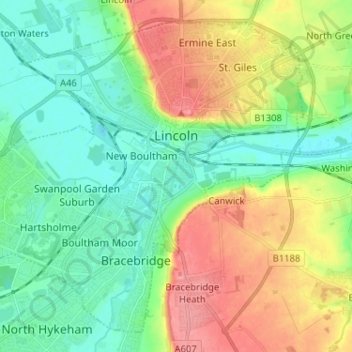
Название: Топографическая карта Lincoln, высота, рельеф.
Местонахождение: Lincoln, Lincolnshire, Greater Lincolnshire, England, United Kingdom (53.18630 -0.62262 53.25455 -0.49392)
Средняя высота: 29 м
Минимальная высота: -1 м
Максимальная высота: 78 м
Другие топографические карты
Нажмите на карту, чтобы просмотреть ее топографию, ее высоту и ее рельеф.
The Lymn
United Kingdom > England > Lincolnshire > East Lindsey > Thorpe St. Peter
Средняя высота: 2 м
Caen Hill
United Kingdom > England > Lincolnshire > West Lindsey > Great Limber CP
Средняя высота: 83 м
Holbeach Clough
United Kingdom > England > Lincolnshire > South Holland > Holbeach CP > Saracen's Head
Средняя высота: 4 м
Moor Barn
United Kingdom > England > Lincolnshire > South Kesteven > Hough-on-the-Hill
Средняя высота: 31 м
Threekingham
United Kingdom > England > Lincolnshire > North Kesteven > Threekingham
Средняя высота: 30 м
Helpringham
United Kingdom > England > Lincolnshire > North Kesteven > Helpringham
Средняя высота: 8 м
Old Somerby
United Kingdom > England > Lincolnshire > South Kesteven > Old Somerby
Средняя высота: 115 м
Shepeau Stow
United Kingdom > England > Lincolnshire > South Holland > Whaplode Drove
Средняя высота: 2 м
Low Fulney Estate
United Kingdom > England > Lincolnshire > South Holland > Spalding
Средняя высота: 4 м