Геолокация

Топографическая карта Walthamstow

Нажмите на карту, чтобы отобразить высоту.

Об этой карте

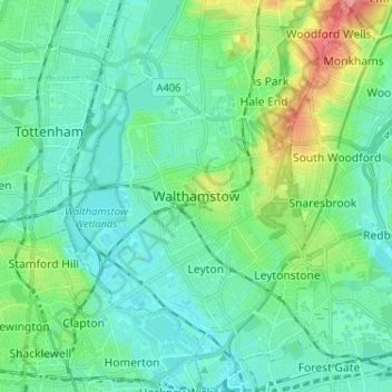
Название: Топографическая карта Walthamstow, высота, рельеф.

Местонахождение: Walthamstow, Greater London, England, E17 3AL, United Kingdom (51.54447 -0.05882 51.62447 0.02118)

Средняя высота: 21 м

Минимальная высота: 3 м

Максимальная высота: 83 м

Другие топографические карты

Нажмите на карту, чтобы просмотреть ее топографию, ее высоту и ее рельеф.

Sheffield

United Kingdom > England

Sheffield nestles on the eastern foothills of the Pennines and is sculpted by a dramatic hill-and-valley system formed where five rivers — the Don, Sheaf, Rivelin, Loxley and Porter — converge, producing steep-sided valleys and gritstone ridgelines with much of the urban area built directly onto hillsides…

Средняя высота: 168 м

Liverpool

United Kingdom > England

Средняя высота: 26 м

Cheshire

United Kingdom > England

Средняя высота: 103 м

Bradford

United Kingdom > England

Средняя высота: 175 м

South East England

United Kingdom > England

Near Weybridge are the UK headquarters of Sony with SSP Group (situated in Byfleet) and Procter & Gamble (next door to each other on The Heights Business Park near the former Brooklands racing circuit) with Kia Motors UK and Petroleum Geo-Services UK, and Gallaher Group (cigarettes) is to the north, next to…

Средняя высота: 69 м

Lancashire

United Kingdom > England

Средняя высота: 153 м

Greater London

United Kingdom > England

Средняя высота: 66 м

Oxford

United Kingdom > England > Oxfordshire

Средняя высота: 81 м

Nottingham

United Kingdom > England > Nottinghamshire

Средняя высота: 56 м

Shrivenham

United Kingdom > England > Oxfordshire > Vale of White Horse

Средняя высота: 97 м

Birmingham

United Kingdom > England

Birmingham is a snowy city relative to other large UK conurbations, due to its inland location and comparatively high elevation. Between 1961 and 1990 Birmingham Airport averaged 13.0 days of snow lying annually, compared to 5.33 at London Heathrow. Snow showers often pass through the city via the Cheshire gap…

Средняя высота: 138 м

Guildford

United Kingdom > England > Surrey

Средняя высота: 74 м

Lake District National Park

United Kingdom > England

The Lake District is a roughly circular upland massif, deeply dissected by a broadly radial pattern of major valleys which are largely the result of repeated glaciations over the last 2 million years. The apparent radial pattern is not from a central dome, but from an axial watershed extending from St Bees…

Средняя высота: 206 м

South Downs National Park

United Kingdom > England > West Sussex

The South Downs National Park's chalk downland is a feature that sets it apart from other national parks in Britain. However, almost a quarter (23%) of the national park consists of a quite different and strongly contrasting physiographic region, the western Weald, whose densely wooded hills and vales are…

Средняя высота: 54 м

Winchester

United Kingdom > England > Hampshire

Средняя высота: 73 м

Greater Manchester

United Kingdom > England

Средняя высота: 141 м

Wakefield

United Kingdom > England

Средняя высота: 88 м

Brighton

United Kingdom > England > Brighton and Hove

Средняя высота: 64 м

Wiltshire

United Kingdom > England

Средняя высота: 115 м

Bristol

United Kingdom > England > City of Bristol

Средняя высота: 55 м

Hampstead Heath

United Kingdom > England > London

Средняя высота: 94 м

Cumbria

United Kingdom > England

Средняя высота: 186 м

Scarborough

United Kingdom > England > North Yorkshire

The climate is temperate with mild summers and cool, windy, winters. The hottest months of the year are July and August, with temperatures reaching an average high of 17 °C and falling to 11 °C at night. The average daytime temperatures in January are 4 °C, falling to 1 °C at night. The station's elevation…

Средняя высота: 50 м

Lincoln

United Kingdom > England > Lincolnshire

Lincoln lies 157 mi (253 km) north of London, at an altitude of 67 ft (20.4 m) by the River Witham up to 246 ft (75.0 m) on Castle Hill. It fills a gap in the Lincoln Cliff escarpment, which runs north and south through central Lincolnshire, with altitudes up to 200 feet (61 metres). The city lies on the River…

Средняя высота: 29 м

Darlington

United Kingdom > England

Средняя высота: 70 м

Shrewsbury Park

United Kingdom > England > Greater London

Средняя высота: 63 м

Connaught Water

United Kingdom > England > Essex > Epping Forest > Sewardstonebury

Средняя высота: 57 м

North East England

United Kingdom > England

North East England has a Marine west coast climate (generally found along the west coast of middle latitude continents) with narrower temperature ranges than the south of England and sufficient precipitation in all months. Summers and winters are mild rather than extremely hot or cold, due to the strong…

Средняя высота: 165 м

Windermere

United Kingdom > England > Cumbria > South Lakeland > Bowness-on-Windermere

There is debate as to whether the stretch of water between Newby Bridge and Lakeside at the southern end of the lake should be considered part of Windermere, or a navigable stretch of the River Leven. This affects the stated length of the lake, which is 11.23 miles (18.07 km) long if measured from the bridge…

Средняя высота: 132 м

Kent

United Kingdom > England

Kent was also the location of the largest number of art schools in the country during the nineteenth century, estimated by the art historian David Haste, to approach two hundred. This is believed to be the result of Kent being a front line county during the Napoleonic Wars. At this time, before the invention…

Средняя высота: 37 м

Worcestershire

United Kingdom > England

Средняя высота: 99 м

Dorset

United Kingdom > England > Talbot Village

Средняя высота: 57 м

Suffolk

United Kingdom > England

The west of the county lies on more resistant Cretaceous chalk. This chalk is responsible for a sweeping tract of largely downland landscapes that stretches from Dorset in the south west to Dover in the south east and north through East Anglia to the Yorkshire Wolds. The chalk is less easily eroded so forms…

Средняя высота: 35 м

Isle of Wight

United Kingdom > England

Средняя высота: 17 м

Somerset

United Kingdom > England

Средняя высота: 87 м

Devon

United Kingdom > England

Средняя высота: 94 м

Cheltenham

United Kingdom > England > Gloucestershire

Средняя высота: 109 м

Oxford

United Kingdom > England > Oxfordshire

Средняя высота: 81 м

Bath

United Kingdom > England > Bath and North East Somerset

Bath is in the Avon Valley and is surrounded by limestone hills as it is near the southern edge of the Cotswolds, a designated Area of Outstanding Natural Beauty, and the limestone Mendip Hills rise around 7 miles (11 km) south of the city. The hills that surround and make up the city have a maximum altitude…

Средняя высота: 100 м

Dover

United Kingdom > England > Kent

Средняя высота: 39 м

Eastbourne

United Kingdom > England > East Sussex

Средняя высота: 36 м

Cambridge

United Kingdom > England > Cambridge

The city, like most of the UK, has a maritime climate highly influenced by the Gulf Stream. Located in the driest region of Britain, Cambridge's rainfall averages around 570 mm (22.44 in) per year, around half the national average, with some years occasionally falling into the semi-arid (under 500 mm (19.69…

Средняя высота: 18 м

Colchester

United Kingdom > England > Essex

Средняя высота: 28 м

Leeds

United Kingdom > England

Средняя высота: 96 м

Newcastle upon Tyne

United Kingdom > England > Tyne and Wear

Средняя высота: 57 м

Penrith

United Kingdom > England > Westmorland and Furness

Средняя высота: 162 м

Southend-on-Sea

United Kingdom > England > Essex

Средняя высота: 12 м

Cofton Hackett CP

United Kingdom > England > Worcestershire > Bromsgrove

Средняя высота: 200 м

Gravesend

United Kingdom > England > Kent > Gravesham

Средняя высота: 31 м

London

United Kingdom > England

London's topography is characterized by a gently rolling terrain shaped by the River Thames and its tributaries. The city lies within the London Basin, a natural depression bordered by higher grounds such as the North Downs to the south and the Chiltern Hills to the northwest. The Thames flows west to east,…

Средняя высота: 66 м

Bury St Edmunds

United Kingdom > England > Suffolk > West Suffolk

The name Bury is etymologically connected with borough, which has cognates in other Germanic languages such as the German burg meaning "fortress, castle"; Old Norse borg meaning "wall, castle"; and Gothic baurg meaning "city". They all derive from Proto-Germanic *burgs meaning "fortress". This in turn derives…

Средняя высота: 54 м

Newbury

United Kingdom > England > West Berkshire

Elevations vary from a minimum of 72 m above mean sea level to 122 m at Wash Common. Elevations reach 150–200 m in the directly adjoining hills. The River Kennet and the Kennet and Avon Canal flow east through the centre of the town to reach the Thames at Reading, while the River Lambourn (beside which is…

Средняя высота: 97 м

Buxton

United Kingdom > England > Derbyshire > High Peak

Buxton has an oceanic climate with short, mild summers and long, cool winters. At about 1,000 feet (300 m) above sea level, As the highest market town in England, Buxton's elevation makes it cooler and wetter than surrounding towns, with a daytime temperature typically about 2 °C lower than Manchester.

Средняя высота: 334 м

East of England

United Kingdom > England

The East of England region has the lowest elevation range in the UK. Twenty percent of the region is below mean sea level, most of this in North Cambridgeshire, Norfolk and on the Essex Coast. Most of the remaining area is of low elevation, with extensive glacial deposits. The Fens, a large area of reclaimed…

Средняя высота: 39 м

North West England

United Kingdom > England

Средняя высота: 118 м

Yorkshire Dales National Park

United Kingdom > England

Средняя высота: 298 м

London

United Kingdom > England

London's topography is characterized by a gently rolling terrain shaped by the River Thames and its tributaries. The city lies within the London Basin, a natural depression bordered by higher grounds such as the North Downs to the south and the Chiltern Hills to the northwest. The Thames flows west to east,…

Средняя высота: 66 м

North York Moors National Park

United Kingdom > England > North Yorkshire

As part of the United Kingdom, the North York Moors area generally has warm summers and relatively mild winters. Weather conditions vary from day to day as well as from season to season. The latitude of the area means that it is influenced by predominantly westerly winds with depressions and their associated…

Средняя высота: 110 м

Brighton and Hove

United Kingdom > England

Средняя высота: 63 м

Gloucestershire

United Kingdom > England

Средняя высота: 99 м

Derbyshire

United Kingdom > England

Due to its central location in England and altitude range from 27 metres in the south to 636 metres in the north, Derbyshire contains many species at the edge of their UK distribution ranges. Some species with a predominantly northern British distribution are at the southern limit of their range, whilst others…

Средняя высота: 144 м

Lincolnshire

United Kingdom > England

Средняя высота: 28 м

Wirral

United Kingdom > England

Средняя высота: 21 м

West Yorkshire

United Kingdom > England

Wakefield's Parish Church was raised to cathedral status in 1888 and after the elevation of Wakefield to diocese, Wakefield Council immediately sought city status and this was granted in July 1888. However the industrial revolution, which changed West and South Yorkshire significantly, led to the growth of…

Средняя высота: 172 м

Dartmoor National Park

United Kingdom > England > Devon

Rainfall tends to be associated with Atlantic depressions or with convection. In summer, convection caused by solar surface heating sometimes forms shower clouds and a large proportion of rainfall falls from showers and thunderstorms at this time of year. The wettest months are November and December and on the…

Средняя высота: 239 м

City of Bristol

United Kingdom > England

Средняя высота: 80 м

Norfolk

United Kingdom > England

Средняя высота: 23 м

Essex

United Kingdom > England

Средняя высота: 44 м

Herefordshire

United Kingdom > England

Средняя высота: 159 м

Surrey

United Kingdom > England > Surrey

The highest elevation in Surrey is Leith Hill near Dorking. It is 295 m (968 ft) above sea level and is the second highest point in southeastern England after Walbury Hill in West Berkshire which is 297 m (974 ft).

Средняя высота: 69 м

Cornwall

United Kingdom > England

The interior of the county consists of a roughly east–west spine of infertile and exposed upland, with a series of granite intrusions, such as Bodmin Moor, which contains the highest land within Cornwall. From east to west, and with approximately descending altitude, these are Bodmin Moor, Hensbarrow north…

Средняя высота: 55 м

Peak District National Park

United Kingdom > England > Derbyshire

Средняя высота: 225 м

Hampshire

United Kingdom > England

Средняя высота: 73 м

Spalding

United Kingdom > England > Lincolnshire > South Holland

Средняя высота: 4 м

Bolton

United Kingdom > England

Средняя высота: 151 м

Exeter

United Kingdom > England > Devon

The city of Exeter was established on the eastern bank of the River Exe on a ridge of land backed by a steep hill. It is at this point that the Exe, having just been joined by the River Creedy, opens onto a wide flood plain and estuary which results in quite common flooding. Historically this was the lowest…

Средняя высота: 56 м

Chichester

United Kingdom > England > West Sussex

Средняя высота: 57 м

Worthing

United Kingdom > England > West Sussex

Средняя высота: 35 м

Borough of Rossendale

United Kingdom > England > Lancashire

Средняя высота: 273 м

Preston

United Kingdom > England > Lancashire

Средняя высота: 58 м

Carlisle

United Kingdom > England > Cumberland

Средняя высота: 31 м

Chesterfield

United Kingdom > England > Derbyshire

Средняя высота: 127 м

Ipswich

United Kingdom > England > Suffolk

Ipswich experiences an oceanic climate, like the rest of the British Isles, with a narrow range of temperature and rainfall spread evenly throughout the year. One of the two nearest for which data is available is East Bergholt, about 7 miles (11 km) south west of the town centre and at a similar elevation, and…

Средняя высота: 29 м

Norwich

United Kingdom > England > Norfolk

Средняя высота: 28 м

Chelmsford

United Kingdom > England > Essex

Средняя высота: 54 м

Dudley

United Kingdom > England

Средняя высота: 146 м

Coventry

United Kingdom > England

Средняя высота: 99 м

Southampton

United Kingdom > England

Средняя высота: 22 м

Edenthorpe

United Kingdom > England > Doncaster

Средняя высота: 12 м

Woolwich Common

United Kingdom > England > Greater London

Средняя высота: 56 м

Chichester

United Kingdom > England > West Sussex

Средняя высота: 57 м

Hertford

United Kingdom > England > Hertfordshire > East Hertfordshire

Средняя высота: 61 м

Haslemere

United Kingdom > England > Surrey > Waverley

Many of the roads in the area originated as medieval tracks and owing to the local topography, are narrow, twisting and steep. The principal route through Haslemere is the A286, which connects the town with Godalming and Grayswood (to the north) and with Midhurst (to the south). The A287 runs south from…

Средняя высота: 150 м

Scampston

United Kingdom > England > North Yorkshire

Средняя высота: 40 м

Newton-le-Willows

United Kingdom > England > North Yorkshire > Newton le Willows

Средняя высота: 100 м

Beechingstoke

United Kingdom > England > Wiltshire

Средняя высота: 111 м

West Overton

United Kingdom > England > Wiltshire > West Overton

Средняя высота: 186 м

Christian Malford

United Kingdom > England > Wiltshire

Средняя высота: 63 м