
Топографическая карта Shillong
Интерактивная карта
Нажмите на карту, чтобы отобразить высоту.
Об этой карте
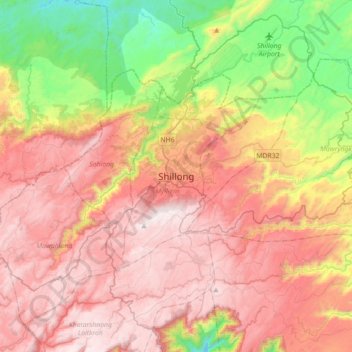
Название: Топографическая карта Shillong, высота, рельеф.
Местонахождение: Shillong, Mylliem, East Khasi Hills District, Meghalaya, 793001, India (25.41604 91.72253 25.73604 92.04253)
Средняя высота: 1 351 м
Минимальная высота: 656 м
Максимальная высота: 1 957 м
HQ Eastern Air Command (HQ, EAC) was shifted to Shillong on 10 Jun 63 from Kolkata and housed in the old buildings located at Nonglyer village at Upper Shillong, some 10 km from (Lower) Shillong, but at a greater altitude of around 6,000 feet AMSL. Initially a British military base, it was taken over by No. 58 Gorkha Regiment of the Indian Army post Independence in 1947. The Regiment was redeployed after the Sino-Indian War of 1962, making way for the IAF to step in. Only helicopters can operate from HQ, EAC, using a 12.7 hectare (31.3 acre) helipad.
Другие топографические карты
Нажмите на карту, чтобы просмотреть ее топографию, ее высоту и ее рельеф.
Sonapani Waterfall Cliff
India > Meghalaya > Mylliem > Shillong
Sonapani Waterfall Cliff, Lower Mawprem, Shillong, Mylliem, East Khasi Hills District, Meghalaya, 793001, India
Средняя высота: 1 402 м