
Топографическая карта Amherst
Интерактивная карта
Нажмите на карту, чтобы отобразить высоту.
Об этой карте
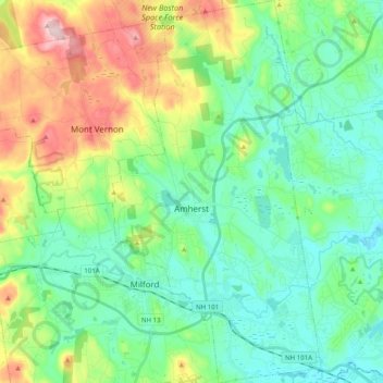
Название: Топографическая карта Amherst, высота, рельеф.
Местонахождение: Amherst, Hillsborough County, New Hampshire, 03031, United States (42.79791 -71.66643 42.94340 -71.55797)
Средняя высота: 127 м
Минимальная высота: 50 м
Максимальная высота: 320 м
According to the United States Census Bureau, the town has a total area of 34.7 square miles (89.9 km2), of which 34.2 square miles (88.5 km2) is land and 0.54 square miles (1.4 km2), or 1.51% of the total area, is water. Located on the Souhegan River, Amherst is drained by Beaver, Bloody, and Joe English brooks. Amherst's highest point is on Chestnut Hill at the town's northern border, where the elevation reaches 865 feet (264 m) above sea level. Amherst lies fully within the Merrimack River watershed.