
Сделать пожертвование
Топографическая карта Gilroy
Нажмите на карту, чтобы отобразить высоту.
Сделать пожертвование
Gilroy
Gilroy is approximately 26 km (16 mi) south of San Jose, California (Bailey Avenue (37.206770, -121.729150) to Monterey/Day Road (37.038210, -121.584480)) on U.S. Route 101 and 31 km (19 mi) inland from the Pacific Coast. Despite its apparent close proximity to San Jose, it is important to note that Gilroy City Hall lies at a distance of 33.3 miles from San Jose City Hall. Lying in a southern extension of the Santa Clara Valley at an elevation of about 61 m (200 ft) above MSL, it is bounded by the Santa Cruz Mountains to the west and the Diablo Range to the east. According to the United States Census Bureau, the city has a total area of 16.2 square miles (42 km2). 16.1 square miles (42 km2) of it is land and 0.06% is water.
Сделать пожертвование
Об этой карте
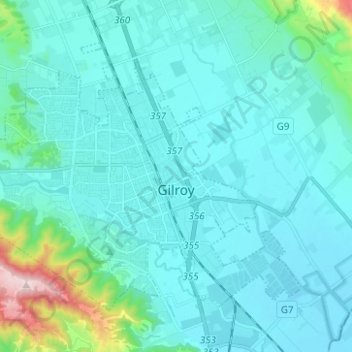
Название: Топографическая карта Gilroy, высота, рельеф.
Местонахождение: Gilroy, Santa Clara County, California, United States (36.97235 -121.64336 37.04821 -121.51880)
Средняя высота: 107 м
Минимальная высота: 41 м
Максимальная высота: 597 м
Сделать пожертвование
Другие топографические карты
Нажмите на карту, чтобы просмотреть ее топографию, ее высоту и ее рельеф.
Santa Cruz Mountains
United States > California > Santa Clara County
The Santa Cruz Mountains are a region of great biological diversity, encompassing cool, moist coastal ecosystems as well as warm, dry chaparral. Much of the area in the Santa Cruz mountains is considered temperate rainforest. In valleys and moist ocean-facing slopes some of the southernmost coast redwoods…
Средняя высота: 230 м
Santa Cruz Mountains
United States > California > Santa Clara County
The Santa Cruz Mountains are a region of great biological diversity, encompassing cool, moist coastal ecosystems as well as warm, dry chaparral. Much of the area in the Santa Cruz mountains is temperate rainforest. In valleys and moist ocean-facing slopes some of the southernmost coast redwoods grow, along…
Средняя высота: 230 м
Сделать пожертвование
Сделать пожертвование
Сделать пожертвование
Morgan Hill
United States > California > Santa Clara County > Morgan Hill
Morgan Hill is approximately 39 km (24 mi) south of downtown San Jose, 21 km (13 mi) north of Gilroy, and 24 km (15 mi) inland from the Pacific coast. Lying in a roughly 6 km-wide (4-mi-wide) southern extension of the Santa Clara Valley, it is bounded by the Santa Cruz Mountains to the west and the Diablo…
Средняя высота: 145 м
Сделать пожертвование
Pacheco Pass
United States > California > Santa Clara County
Pacheco Pass, elevation 1,368 ft (417 m), is a low mountain pass located in the Diablo Range in southeastern Santa Clara County, California. It is the main route through the hills separating the Santa Clara Valley and the Central Valley.
Средняя высота: 425 м
Сделать пожертвование
Сделать пожертвование
Сделать пожертвование
Vasona Lake County Park
United States > California > Santa Clara County > Los Gatos > Shannon
Средняя высота: 109 м
Coyote
United States > California > Santa Clara County
Due to the moderating influence of the Pacific Ocean, Coyote enjoys a mild, Mediterranean climate. Temperatures range from an average midsummer maximum of 32.3°C (90.2°F) to an average midwinter low of 0.9 °C (33.6 °F). Average annual precipitation is 480 mm (18.9 in), and the summer months are typically…
Средняя высота: 131 м
Сделать пожертвование
Lexington Hills
United States > California > Santa Clara County > Redwood Estates
Средняя высота: 424 м
Сделать пожертвование
Сделать пожертвование
Los Altos Hills
United States > California > Santa Clara County > Los Altos Hills > Los Altos Hills
Средняя высота: 94 м