
Сделать пожертвование
Топографическая карта Montgomery Center
Нажмите на карту, чтобы отобразить высоту.
Сделать пожертвование
Об этой карте
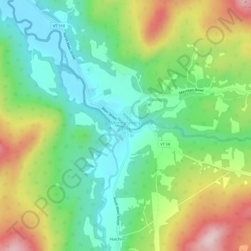
Название: Топографическая карта Montgomery Center, высота, рельеф.
Местонахождение: Montgomery Center, Montgomery, Franklin County, Vermont, 05471, United States (44.85754 -72.62802 44.89754 -72.58802)
Средняя высота: 269 м
Минимальная высота: 143 м
Максимальная высота: 487 м
Сделать пожертвование
Другие топографические карты
Нажмите на карту, чтобы просмотреть ее топографию, ее высоту и ее рельеф.
Fletcher
United States > Vermont > Franklin County
Fletcher is located in southern Franklin County, bordered to the southeast by Lamoille County. According to the United States Census Bureau, the town has a total area of 38.0 square miles (98.4 km2), of which 37.7 square miles (97.7 km2) is land and 0.3 square miles (0.7 km2), or 0.71%, is water. The Lamoille…
Средняя высота: 229 м
Сделать пожертвование
Missisquoi River
United States > Vermont > Franklin County
The Missisquoi River rises in western Orleans County, Vermont, northwest of Lowell, Vermont, at an altitude of 247 metres (810 ft). This source is located next to Route 58 and adjacent to Belvidere Mountain. This source proves to be the continuity of the Burgess Branch (coming from the southwest).
Средняя высота: 277 м
Сделать пожертвование
Fletcher
United States > Vermont > Franklin County
Fletcher is located in southern Franklin County, bordered to the southeast by Lamoille County. According to the United States Census Bureau, the town has a total area of 38.0 square miles (98.4 km2), of which 37.7 square miles (97.7 km2) is land and 0.3 square miles (0.7 km2), or 0.71%, is water. The Lamoille…
Средняя высота: 229 м
Сделать пожертвование
Сделать пожертвование