
Сделать пожертвование
Топографическая карта Soglio
Нажмите на карту, чтобы отобразить высоту.
Сделать пожертвование
Об этой карте
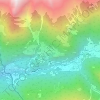
Название: Топографическая карта Soglio, высота, рельеф.
Местонахождение: Soglio, Bregaglia, Maloja, Grisons, 7610, Switzerland (46.32207 9.51988 46.36207 9.55988)
Средняя высота: 1 357 м
Минимальная высота: 659 м
Максимальная высота: 2 612 м
Сделать пожертвование
Другие топографические карты
Нажмите на карту, чтобы просмотреть ее топографию, ее высоту и ее рельеф.
Sankt Moritz
Switzerland > Grisons > Maloja
St. Moritz (also German: Sankt Moritz, Romansh: San Murezzan (help·info), Italian: San Maurizio, French: Saint-Moritz) is a high Alpine resort town in the Engadine in Switzerland, at an elevation of about 1,800 metres (5,910 ft) above sea level. It is Upper Engadine's major town and a municipality in the…
Средняя высота: 2 173 м
Sankt Moritz
Switzerland > Grisons > Maloja
St. Moritz (/ˌsæn məˈrɪts/ SAN mə-RITS, US also /ˌseɪnt -/ SAYNT -, UK also /sənt ˈmɒrɪts/ sənt MORR-its; German, in full: Sankt Moritz [zaŋkt moˈrɪts, ˈmoːrɪts] locally [saŋkt]; Romansh: San Murezzan [sam muˈʁetsən] ; Italian: San Maurizio; French: Saint-Moritz) is a high Alpine…
Средняя высота: 2 173 м
Pontresina
Switzerland > Grisons > Maloja
Before 2017, the municipality was located in the Oberengadin sub-district of the Maloja district, after 2017 it was part of the Maloja Region. It sits in Val Bernina, which is the highest altitude valley that branches off the Upper Engadin Valley. The municipality includes the highest mountain of the canton,…
Средняя высота: 2 580 м
Сделать пожертвование
Pontresina
Switzerland > Grisons > Maloja
Before 2017, the municipality was located in the Oberengadin sub-district of the Maloja district, after 2017 it was part of the Maloja Region. It sits in Val Bernina, which is the highest altitude valley that branches off the Upper Engadin Valley. The municipality includes the highest mountain of the canton,…
Средняя высота: 2 580 м
Sankt Moritz
Switzerland > Grisons > Maloja
St. Moritz (/ˌsæn məˈrɪts/ SAN mə-RITS, US also /ˌseɪnt -/ SAYNT -, UK also /sənt ˈmɒrɪts/ sənt MORR-its; German, in full: Sankt Moritz [zaŋkt moˈrɪts, ˈmoːrɪts] locally [saŋkt]; Romansh: San Murezzan [sam muˈʁetsən] ; Italian: San Maurizio; French: Saint-Moritz) is a high Alpine…
Средняя высота: 2 173 м
Pontresina
Switzerland > Grisons > Maloja
Before 2017, the municipality was located in the Oberengadin sub-district of the Maloja district, after 2017 it was part of the Maloja Region. It sits in Val Bernina, which is the highest altitude valley that branches off the Upper Engadin Valley. The municipality includes the highest mountain of the canton,…
Средняя высота: 2 580 м
Сделать пожертвование
Сделать пожертвование
Lägh dal Lunghin
Switzerland > Grisons > Maloja
Lägh dal Lunghin (German: Lunghinsee) is a lake at an elevation of 2484 m, below the peak of Piz Lunghin, in the Graubünden, Switzerland. It is considered the source of the Inn River.
Средняя высота: 2 456 м