
Сделать пожертвование
Топографическая карта Devonport
Нажмите на карту, чтобы отобразить высоту.
Сделать пожертвование
Об этой карте
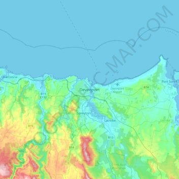
Название: Топографическая карта Devonport, высота, рельеф.
Местонахождение: Devonport, City of Devonport, Tasmania, 7310, Australia (-41.33976 146.20130 -41.01976 146.52130)
Средняя высота: 67 м
Минимальная высота: -4 м
Максимальная высота: 478 м
Сделать пожертвование
Другие топографические карты
Нажмите на карту, чтобы просмотреть ее топографию, ее высоту и ее рельеф.
Tasmania
The most mountainous region is the Central Highlands area, which covers most of the central western parts of the state. The Midlands located in the central east, is fairly flat, and is predominantly used for agriculture, although farming activity is scattered throughout the state. Tasmania's tallest mountain…
Средняя высота: 220 м
Сделать пожертвование
Сделать пожертвование
Hobart
Although Hobart itself rarely receives snow during the winter due to the foehn effect created by the Central Highlands (the city's geographic position causes a rainshadow), the adjacent Kunanyi/Mount Wellington is frequently seen with a snowcap throughout the year including in summer. During the 20th century,…
Средняя высота: 179 м
Launceston
Launceston is at 41°26′31″S 147°8′42″E / 41.44194°S 147.14500°E / -41.44194; 147.14500 in the Tamar Valley, Northern Tasmania. The valley was formed by volcanic and glacial forces over 10 million years ago. The city is about 45 kilometres (28 mi) south of the Bass Strait, with its closest…
Средняя высота: 194 м
Сделать пожертвование
Сделать пожертвование
Сделать пожертвование
Сделать пожертвование
Сделать пожертвование
Сделать пожертвование
Macquarie Island
Macquarie Island is about 34 km (21 mi) long and 5 km (3 mi) wide, with an area of 128 km2 (49 sq mi). The island consists of plateaus at north and south ends, each of 150–200 m (490–660 ft) elevation, joined by a low, narrow isthmus. The high points include Mount Elder on the north-east coastal ridge at…
Средняя высота: 20 м
Сделать пожертвование
Сделать пожертвование
Сделать пожертвование
Сделать пожертвование
Сделать пожертвование
Launceston
Launceston is at 41°26′31″S 147°8′42″E / 41.44194°S 147.14500°E / -41.44194; 147.14500 in the Tamar Valley, Northern Tasmania. The valley was formed by volcanic and glacial forces over 10 million years ago. The city is about 45 kilometres (28 mi) south of the Bass Strait, with its closest…
Средняя высота: 26 м
Сделать пожертвование
Сделать пожертвование
Three Hummock Island
The island is named after its three most prominent hills, North, Middle and South Hummock, the latter being the highest, with an elevation of 237 metres (778 ft) above mean sea level. From the mid-19th century until the mid-1970s, most of the island was subject to a pastoral lease, allowing farming and grazing…
Средняя высота: 22 м
Сделать пожертвование
Hobart
Although Hobart itself rarely receives snow during the winter due to the foehn effect created by the Central Highlands (the city's geographic position causes a rainshadow), the adjacent Kunanyi/Mount Wellington is frequently seen with a snowcap throughout the year including in summer. During the 20th century,…
Средняя высота: 31 м
Сделать пожертвование
Сделать пожертвование
Сделать пожертвование
Сделать пожертвование
Сделать пожертвование
Сделать пожертвование
Сделать пожертвование
Сделать пожертвование
Сделать пожертвование