
Сделать пожертвование
Топографическая карта Vatva Taluka
Нажмите на карту, чтобы отобразить высоту.
Сделать пожертвование
Об этой карте
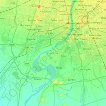
Название: Топографическая карта Vatva Taluka, высота, рельеф.
Местонахождение: Vatva Taluka, Ahmedabad, Gujarat, India (22.91472 72.51230 23.03326 72.69471)
Средняя высота: 44 м
Минимальная высота: 28 м
Максимальная высота: 76 м
Сделать пожертвование
Другие топографические карты
Нажмите на карту, чтобы просмотреть ее топографию, ее высоту и ее рельеф.
Сделать пожертвование
Dhari
India > Gujarat > Dhari Taluka
Dhari is located at 21°19′36″N 71°01′31″E / 21.3266°N 71.0253°E / 21.3266; 71.0253. It has an average elevation of 216m (708') above sea level. The city is located in Saurashtra region of Gujarat and is situated near the Shetrunji River, which is passes north of Palitana's hills,…
Средняя высота: 221 м
Сделать пожертвование
Surat
India > Gujarat > Katargam Taluka > Surat
Surat is a port city situated on the banks of the Tapi river. Damming of the Tapi caused the original port facilities to close; the nearest port is now in the Magadalla and Hazira area of Surat Metropolitan Region.It has famous beach called 'Dumas Beach' located in Hazira. The city is located at 21°10′N…
Средняя высота: 11 м
Vadodara
India > Gujarat > Vadodara Rural Taluka
Vadodara is located at 22°18′N 73°11′E / 22.30°N 73.19°E / 22.30; 73.19 in western India at an elevation of 39 metres (128 ft). It is the tenth-largest city in India with an area of 400 square kilometres (150 sq mi) and a population of 3.5 million, according to the 2010–11 census. The city…
Средняя высота: 36 м
Сделать пожертвование
Anand
India > Gujarat > Anand City Taluka
Anand is located at 22°34′N 72°56′E / 22.57°N 72.93°E / 22.57; 72.93. It has an average elevation of 39 metres (127 feet). The city has an area of 22.7 square kilometres, and the urban area of Anand City is 172 square kilometres including 25 villages around the city.
Средняя высота: 40 м
Сделать пожертвование
Bhuj
India > Gujarat > Bhuj Taluka
Bhuj has an average elevation of 110 metres (360 feet). On the eastern side of the city is a hill known as Bhujia Hill, on which there is a Bhujia Fort, that separates Bhuj city and Madhapar town ( considered one of the richest villages in Asia ). It has two lakes namely Hamirsar and Deshadsar (દેેેશળસર).
Средняя высота: 130 м
Dholka
India > Gujarat > Dholka Taluka
Dholka is a City and municipality in the Ahmedabad District of the Indian state of Gujarat. It is the headquarters of Dholka Taluka, and is 48 km by road via National Highway 8A southwest of the city of Ahmedabad. Dholka has an average elevation of 17 metres (56 ft).
Средняя высота: 22 м
Сделать пожертвование
Bhavnagar
India > Gujarat > Bhavnagar Taluka
Bhavnagar is a coastal city on the eastern coast of Saurashtra, also known as Kathiawar, located at 21°46′N 72°09′E / 21.77°N 72.15°E / 21.77; 72.15. It has an average elevation of 24 metres (78 ft). It occupies an area of 53.3 km2 (20.6 sq mi) and 5th most populated city of Gujarat. The…
Средняя высота: 23 м
Сделать пожертвование
Сделать пожертвование
Dwarka
India > Gujarat > Okhamandal Taluka
Considered a holy city, Dwarka is well known for its temples and as a pilgrimage centre for Hindus. The Dwarakadhisa Temple, also called Jagat Mandir, located in the heart of Dwarka, is a Vaishnava temple. It was built by Raja Jagat Singh Rathore, hence it is called Jagat Mandir. The temple, facing west, is at…
Средняя высота: 3 м
Gandhinagar
India > Gujarat > Gandhinagar Taluka > Gandhinagar
Gandhinagar has an average elevation of 81 metres (266 feet). The city sits on the banks of the Sabarmati River, in north-central-east Gujarat. The 20,543 km2 area around Gandhinagar is defined by Gujarat capital territory. It spans an area of 205 km2 (79 sq mi). The river frequently dries up in the summer,…
Средняя высота: 76 м
Сделать пожертвование
Сделать пожертвование
Сделать пожертвование
Junagadh
India > Gujarat > Junagadh City Taluka
Junagadh city is located at 21°31′N 70°28′E / 21.52°N 70.47°E / 21.52; 70.47 at the foot of Mount Girnar, with the Arabian sea to the southwest, Porbandar to the north, and Amreli to the east. It has an average elevation of 107 metres (351 ft).
Средняя высота: 163 м
Bharuch
India > Gujarat > Bharuch Taluka
Bharuch is located at 21°42′N 72°58′E / 21.7°N 72.97°E / 21.7; 72.97. It has an average elevation of 15 metres (49 feet). Bharuch is a port city situated on the banks of the Narmada river. The damming of the Narmada caused the original port facilities to close, the nearest port is now in…
Средняя высота: 15 м
Сделать пожертвование
Сделать пожертвование
Сделать пожертвование
Gandhinagar
India > Gujarat > Gandhinagar Taluka
Gandhinagar has an average elevation of 81 metres (266 feet). The city sits on the banks of the Sabarmati River, in north-central-east Gujarat. The 20,543 km2 area around Gandhinagar is defined by Gujarat capital territory. Gandhinagar spans an area of 326 km2 (126 sq mi). The river frequently dries up in the…
Средняя высота: 75 м
Kutiyana
India > Gujarat > Kutiyana Taluka
Kutiyana is located at 21°38′N 69°59′E / 21.63°N 69.98°E / 21.63; 69.98. It has an average elevation of 30 metres (98 feet). Kutiyana town is spread over almost a 2 km range on the banks of the Bhadar River. Kutiyana is around 42 km away from its district center, Porbandar, and 40 km away from…
Средняя высота: 19 м
Сделать пожертвование
Visavadar
India > Gujarat > Visavadar Taluka
Visavadar is located at 21°23′N 70°41′E / 21.38°N 70.68°E / 21.38; 70.68. It has an average elevation of 91 metres (298 feet).
Средняя высота: 145 м
Сделать пожертвование
Сделать пожертвование
Сделать пожертвование
Surat
India > Gujarat > Katargam Taluka
Surat is a port city situated on the banks of the Tapi river. Damming of the Tapi caused the original port facilities to close; the nearest port is now in the Magadalla and Hazira area of Surat Metropolitan Region. It has a famous beach called 'Dumas Beach' located in Hazira. The city is located at…
Средняя высота: 13 м
Сделать пожертвование
Сделать пожертвование
Сделать пожертвование
Сделать пожертвование
Сделать пожертвование
Surat
India > Gujarat > Katargam Taluka
Surat is a port city situated on the banks of the Tapi river. After dams were built, water flow in Tapi deceased causing the original port facilities to close. The nearest port is now in the Magadalla and Hazira area of Surat Metropolitan Region. It has a famous beach called 'Dumas Beach' located in Dumas.The…
Средняя высота: 13 м
Сделать пожертвование
Сделать пожертвование
Modasa
India > Gujarat > Modasa Taluka
Modasa is located at 23°28′N 73°18′E / 23.47°N 73.3°E / 23.47; 73.3. It has an average elevation of 197 metres (646 feet). Most of the water for Modasa comes from the Mazum river, on which, about 5 kilometers from Modasa, the Mazum reservoir is situated.
Средняя высота: 149 м
Ambaji
India > Gujarat > Danta Taluka
Ambaji is a town within taluka district Banaskantha, North Gujarat, India. It is located at 24°20′N 72°51′E / 24.33°N 72.85°E / 24.33; 72.85. It is at an altitude of 480 metres (1,570 ft). It is surrounded by the Araveli Hill range. Ambaji is within the Aravali Range'line of peaks', is a range…
Средняя высота: 453 м
Сделать пожертвование