
Сделать пожертвование
Топографическая карта Gunten
Нажмите на карту, чтобы отобразить высоту.
Сделать пожертвование
Об этой карте
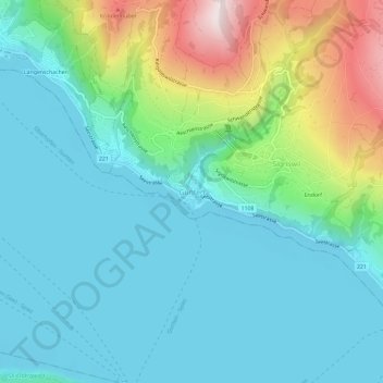
Название: Топографическая карта Gunten, высота, рельеф.
Средняя высота: 694 м
Минимальная высота: 548 м
Максимальная высота: 1 169 м
Сделать пожертвование
Другие топографические карты
Нажмите на карту, чтобы просмотреть ее топографию, ее высоту и ее рельеф.
Sigriswil
Switzerland > Bern > Thun administrative district
Archeological remains dating from the Late Neolithic and Bronze Age show that the area around Sigriswil has been inhabited as early as 5000 years ago. It's thought that the first modern inhabitants can be traced back to Alamanni tribesmen who settled on the banks of Thun lake around the 5th Century A.D., later…
Средняя высота: 959 м
Thun
Switzerland > Bern > Thun administrative district
The center of Thun is located on the Aare, just downstream of the point where that river flows out of Lake Thun, and encompasses both banks of the river and an island between. The town covers an area of 21.6 km2 (8.3 sq mi), with the town boundaries reaching up to 4 km (2.5 mi) from the town centre. The town…
Средняя высота: 637 м
Сделать пожертвование