
Спасибо за поддержку этого сайта ❤️
Сделать пожертвование
Сделать пожертвование
Топографическая карта Lausanne
Нажмите на карту, чтобы отобразить высоту.
Спасибо за поддержку этого сайта ❤️
Сделать пожертвование
Сделать пожертвование
Lausanne
The most important geographical feature of the area surrounding Lausanne is Lake Geneva (Lac Léman in French). Lausanne is built on the southern slope of the Swiss plateau, with a difference in elevation of about 500 metres (1,640 ft) between the lakeshore at Ouchy and its northern edge bordering Le Mont-sur-Lausanne and Épalinges. Lausanne boasts a dramatic panorama over the lake and the Swiss and Savoyan Alps.
Спасибо за поддержку этого сайта ❤️
Сделать пожертвование
Сделать пожертвование
Об этой карте
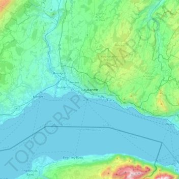
Название: Топографическая карта Lausanne, высота, рельеф.
Местонахождение: Lausanne, District de Lausanne, Vaud, 1003, Switzerland (46.36183 6.47270 46.68183 6.79270)
Средняя высота: 577 м
Минимальная высота: 367 м
Максимальная высота: 1 958 м
Спасибо за поддержку этого сайта ❤️
Сделать пожертвование
Сделать пожертвование