
Сделать пожертвование
Топографическая карта Marbella
Нажмите на карту, чтобы отобразить высоту.
Сделать пожертвование
Marbella
There are five geomorphological areas in Marbella—the Sierra Blanca, the Sierra Blanca piedmont (foothills), the lower hill country, the plains and the coastal dunes. The Sierra Blanca is the most centrally-located in the province, peaking behind the old village. The mountain range has three notable peaks—La Concha, located further west at 1,215 m (3,986 feet) above sea level, Juanar Cross, located eastward (within the municipality of Ojen) at 1,178 m (3,865 feet) above sea level, and the highest, Mount Lastonar, located between the two at 1,270 m (4,170 feet). Marbella's topography is characterised by extensive coastal plains formed from eroded mountains. North of the plain is an area of around 100 and 400 m (330 and 1,300 feet) above sea level, encompassing low, rolling hills, with higher foothills and steeper slopes approaching the mountains behind. The coast is generally low-lying, with sandy beaches that are more extensive further east, between the fishing port and Cabopino. Despite the intense urbanisation of the coast, it still retains a natural area of dunes, the Artola Dunes (Dunas de Artola), at the eastern end of town.
Сделать пожертвование
Об этой карте
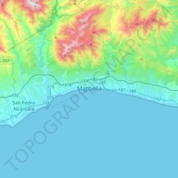
Название: Топографическая карта Marbella, высота, рельеф.
Местонахождение: Marbella, Costa del Sol Occidental, Malaga, Andalusia, Spain (36.46001 -5.01467 36.55497 -4.73057)
Средняя высота: 216 м
Минимальная высота: -1 м
Максимальная высота: 1 319 м
Сделать пожертвование
Другие топографические карты
Нажмите на карту, чтобы просмотреть ее топографию, ее высоту и ее рельеф.
Сделать пожертвование
Сделать пожертвование
Сделать пожертвование
Casares del Sol
Spain > Andalusia > Costa del Sol Occidental > Casares > Casares del Sol
Средняя высота: 41 м
Urbanizacion Playa Mijas
Spain > Andalusia > Costa del Sol Occidental > Urbanización Chaparral > Urbanizacion Playa Mijas
Средняя высота: 27 м
Сделать пожертвование