
Топографическая карта Shrewsbury
Нажмите на карту, чтобы отобразить высоту.
Shrewsbury
Shrewsbury is about 14 miles (23 km) west of Telford, 43 miles (69 km) west of Birmingham and the West Midlands Conurbation, and about 153 miles (246 km) north-west of the capital, London. More locally, the town is to the east of Welshpool, with Bridgnorth and Kidderminster to the south-east. The border with Wales is 9 miles (14 km) to the west. The town centre is partially built on a hill whose elevation is, at its highest, 246 feet (75 m) above sea level. The longest river in the UK, the River Severn, flows through the town, forming a meander around its centre. The town is subject to flooding from the river.
Об этой карте
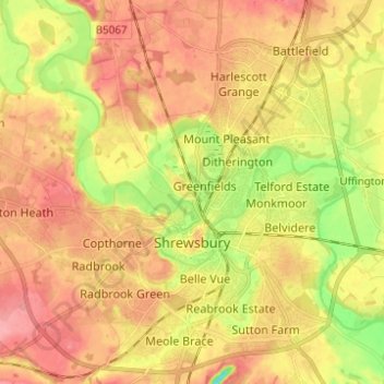
Название: Топографическая карта Shrewsbury, высота, рельеф.
Местонахождение: Shrewsbury, Shropshire, England, United Kingdom (52.68019 -2.82004 52.75498 -2.70122)
Средняя высота: 69 м
Минимальная высота: 19 м
Максимальная высота: 103 м
Другие топографические карты
Нажмите на карту, чтобы просмотреть ее топографию, ее высоту и ее рельеф.
Minton
United Kingdom > England > Shropshire > Church Stretton > Little Stretton
Средняя высота: 272 м