
Топографическая карта Karamay
Интерактивная карта
Нажмите на карту, чтобы отобразить высоту.
Об этой карте
Название: Топографическая карта Karamay, высота, рельеф.
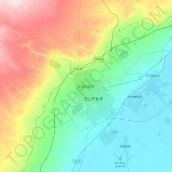
Местонахождение: Karamay, Karamay District, Karamay City, Xinjiang, China (45.44038 84.70614 45.76038 85.02614)
Средняя высота: 510 м
Минимальная высота: 267 м
Максимальная высота: 1 097 м
Karamay is located in the northwest of the Dzungarian basin, with an average elevation of 400 meters (1,300 ft). Its administrative area ranges in latitude from 44° 07' to 46° 08' N and in longitude from 80° 44' to 86° 01' E, and has a maximal 240 km (150 mi) north-south extent and reaches 110 km (68 mi) in east-west width. It borders Hoboksar Mongol Autonomous County to the northeast, Shawan County to the southeast, Toli County and Wusu to the west, and Kuytun to the south.