
Топографическая карта Sca Fell
Интерактивная карта
Нажмите на карту, чтобы отобразить высоту.
Sca Fell
The route from Scafell Pike to Scafell (or its reverse) is one of the most frustrating in the Lake District. What seems like a direct route is in fact very hazardous as it has to negotiate Broad Stand crag, which is a dangerous and exposed scramble that has caused many accidents and injuries. It is usually treated as a rock climb, with appropriate ropes and belay protection. Wainwright warns against its dangers to walkers. Its dangers are more obvious travelling from Scafell Pike, but travelling from Scafell, the route loses a lot of height before the danger is seen. Instead there are two walking routes, but they entail some loss of altitude. The first is via Foxes Tarn to the East of Scafell summit, and the second is via Lord's Rake and the West Wall traverse. All routes go via Mickledore.
Об этой карте
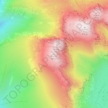
Название: Топографическая карта Sca Fell, высота, рельеф.
Местонахождение: Sca Fell, Cumberland, England, CA20 1EX, United Kingdom (54.44746 -3.22476 54.44756 -3.22466)
Средняя высота: 619 м
Минимальная высота: 226 м
Максимальная высота: 970 м
Другие топографические карты
Нажмите на карту, чтобы просмотреть ее топографию, ее высоту и ее рельеф.
Crinkle Crags
United Kingdom > England > Cumberland > Ulpha
In recent times more systematic hill lists have been produced based upon topographical prominence and height, rather than mere visual appeal. Most relevant to Crinkle Crags are the lists of Hewitts and Nuttalls. These variously list the summit, the first Crinkle (Crinkle Crags South Top), and two tops on…
Средняя высота: 566 м
Burnmoor Tarn
United Kingdom > England > Cumberland
The tarn is one of the sites in DEFRA's UK Upland Waters Monitoring Network. It occupies 23.9 hectares (59 acres) and lies at an altitude of 253 metres (830 ft) in a moraine hollow on the uplands between Wastwater and Eskdale. The lake has two distinct basins close to the south-eastern shore and a maximum…
Средняя высота: 345 м
Blindcrake
United Kingdom > England > Cumberland
The Isel valley has a temperate climate like much of the UK. However, it is one of the driest and sunniest parts of the Lake District. Summers are typically warm with some rain, with late spring to mid-summer tending to be the driest time of the year. Winters can be mild and wet, but due to the areas…
Средняя высота: 131 м
Cockermouth
United Kingdom > England > Cumberland
Cockermouth has a temperate climate that is influenced by the Irish Sea and its low-lying elevation. Cockermouth receives slightly below average rainfall compared with the UK average. Temperatures are also round about average compared with other parts of the UK. The nearest weather station for which online…
Средняя высота: 86 м