
Сделать пожертвование
Топографическая карта Sacramento County
Нажмите на карту, чтобы отобразить высоту.
Сделать пожертвование
Sacramento County
According to the U.S. Census Bureau, the county has a total area of 994 square miles (2,570 km2), of which 965 square miles (2,500 km2) is land and 29 square miles (75 km2) (3.0%) is water. Most of the county is at an elevation close to sea level, with some areas below sea level. The highest point in the county is Carpenter Hill at 828 feet (252 m), in the southeast part of Folsom. Major watercourses in the county include the American River, Sacramento River, Cosumnes River, a tributary of the Mokelumne River, and Dry Creek, a tributary of the Sacramento River.
Сделать пожертвование
Об этой карте
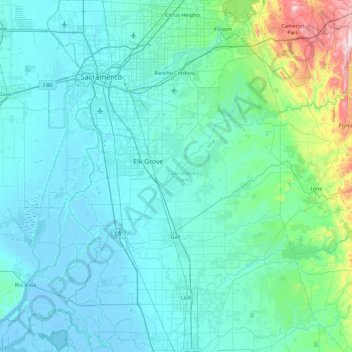
Название: Топографическая карта Sacramento County, высота, рельеф.
Местонахождение: Sacramento County, California, United States of America (38.01827 -121.86281 38.73635 -121.02708)
Средняя высота: 62 м
Минимальная высота: -8 м
Максимальная высота: 610 м
Сделать пожертвование
Другие топографические карты
Нажмите на карту, чтобы просмотреть ее топографию, ее высоту и ее рельеф.
San Mateo Highlands
United States of America > California > San Mateo Highlands > Highlands
Средняя высота: 129 м