
Спасибо за поддержку этого сайта ❤️
Сделать пожертвование
Сделать пожертвование
Топографическая карта Cedar City
Нажмите на карту, чтобы отобразить высоту.
Спасибо за поддержку этого сайта ❤️
Сделать пожертвование
Сделать пожертвование
Cedar City
Cedar City is located in the southeast Great Basin and is approximately 20 miles (32 km) north of the northeastern edge of the Mojave Desert. Its elevation of 5,846 feet (1,782 m) gives it a somewhat cooler climate compared to the nearby St. George region, though it retains cultural ties to the city —for example, they share a daily newspaper.
Спасибо за поддержку этого сайта ❤️
Сделать пожертвование
Сделать пожертвование
Об этой карте
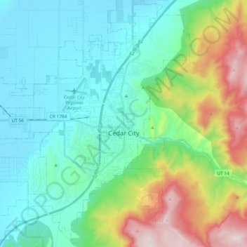
Название: Топографическая карта Cedar City, высота, рельеф.
Местонахождение: Cedar City, Iron County, Utah, United States (37.61847 -113.19797 37.74748 -113.01272)
Средняя высота: 1 975 м
Минимальная высота: 1 676 м
Максимальная высота: 2 866 м
Спасибо за поддержку этого сайта ❤️
Сделать пожертвование
Сделать пожертвование
Другие топографические карты
Нажмите на карту, чтобы просмотреть ее топографию, ее высоту и ее рельеф.