
Топографическая карта Jerome
Интерактивная карта
Нажмите на карту, чтобы отобразить высоту.
Об этой карте
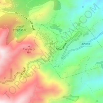
Название: Топографическая карта Jerome, высота, рельеф.
Местонахождение: Jerome, Yavapai County, Arizona, 86331, United States (34.73958 -112.11939 34.75395 -112.09424)
Средняя высота: 1 574 м
Минимальная высота: 1 291 м
Максимальная высота: 1 930 м
Jerome is about 100 miles (160 km) north of Phoenix and 45 miles (72 km) southwest of Flagstaff along Arizona State Route 89A between Sedona to the east and Prescott to the west. The town is in Arizona's Black Hills, which trend north–south. The town lies within the Prescott National Forest at an elevation of more than 5,000 feet (1,500 m). Woodchute Wilderness is about 3 miles (5 km) west of Jerome, and Mingus Mountain, at 7,726 feet (2,355 m) above sea level, is about 4 miles (6 km) south of town. Jerome State Historic Park is in the town itself. Bitter Creek, a tributary of the Verde River, flows intermittently through Jerome. East of Jerome at the base of the hills are the Verde Valley and the communities of Clarkdale and Cottonwood, site of the nearest airport.
Другие топографические карты
Нажмите на карту, чтобы просмотреть ее топографию, ее высоту и ее рельеф.
Glen Oaks
United States > Arizona > Yavapai County
Glen Oaks, Yavapai County, Arizona, United States
Средняя высота: 1 717 м
Camp Verde
United States > Arizona > Yavapai County
Camp Verde, Yavapai County, Arizona, 86322, United States
Средняя высота: 1 095 м
Cordes
United States > Arizona > Yavapai County
Cordes, Yavapai County, Arizona, 86333, United States
Средняя высота: 1 170 м
Ocotillo
United States > Arizona > Yavapai County
Ocotillo, Yavapai County, Arizona, United States
Средняя высота: 1 302 м
Paulden
United States > Arizona > Yavapai County
Paulden, Yavapai County, Arizona, United States
Средняя высота: 1 408 м
Wagoner
United States > Arizona > Yavapai County > Wagoner
Wagoner, Yavapai County, Arizona, United States
Средняя высота: 1 063 м
Prescott Valley
United States > Arizona > Yavapai County
Prescott Valley, Yavapai County, Arizona, United States
Средняя высота: 1 550 м
Ash Fork
United States > Arizona > Yavapai County > Ash Fork
Ash Fork, Yavapai County, Arizona, 86320, United States
Средняя высота: 1 561 м
Dewey
United States > Arizona > Yavapai County > Prescott Valley > Dewey
Dewey, Prescott Valley, Yavapai County, Arizona, 86329, United States
Средняя высота: 1 415 м
Sedona
United States > Arizona > Yavapai County
Sedona, Yavapai County, Arizona, 86336, United States
Средняя высота: 1 342 м
Cleator
United States > Arizona > Yavapai County
Cleator, Yavapai County, Arizona, United States
Средняя высота: 1 083 м
Pica
United States > Arizona > Yavapai County
Pica, Yavapai County, Arizona, United States
Средняя высота: 1 613 м
Prescott
United States > Arizona > Yavapai County
Prescott, Yavapai County, Arizona, United States
Средняя высота: 1 674 м
Audley
United States > Arizona > Yavapai County
Audley, Yavapai County, Arizona, 96337, United States
Средняя высота: 1 591 м