
Сделать пожертвование
Топографическая карта Periya
Нажмите на карту, чтобы отобразить высоту.
Сделать пожертвование
Об этой карте
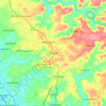
Название: Топографическая карта Periya, высота, рельеф.
Местонахождение: Periya, Hosdurg, Kasaragod, Kerala, 671320, India (12.36164 75.05729 12.44164 75.13729)
Средняя высота: 60 м
Минимальная высота: 3 м
Максимальная высота: 136 м
Сделать пожертвование
Другие топографические карты
Нажмите на карту, чтобы просмотреть ее топографию, ее высоту и ее рельеф.
Kanhangad
India > Kerala > Hosdurg > Kallanchira
Kanhangad lies at 12°18′0″N 75°5.4′0″E in the geographic map of Kasaragod. It is a coastal town which has a varied topography with plain areas in the centre of the city. The landscape is dominated by the characteristic coconut palms accompanying rolling hills and streams flowing into the sea. In the…
Средняя высота: 19 м
Сделать пожертвование
Kanhangad
India > Kerala > Hosdurg > ലക്ഷ്മിനഗരം
Kanhangad lies at 12°18′0″N 75°5.4′0″E in the geographic map of Kasaragod. It is a coastal town which has a varied topography with plain areas in the centre of the city. The landscape is dominated by the characteristic coconut palms accompanying rolling hills and streams flowing into the sea. In the…
Средняя высота: 19 м
Kanhangad
India > Kerala > Hosdurg > Kanhangad
Kanhangad lies at 12°18′0″N 75°5.4′0″E in the geographic map of Kasaragod. It is a coastal town which has a varied topography with plain areas in the centre of the city. The landscape is dominated by the characteristic coconut palms accompanying rolling hills and streams flowing into the sea. In the…
Средняя высота: 19 м