
Сделать пожертвование
Топографическая карта Palm Springs
Нажмите на карту, чтобы отобразить высоту.
Сделать пожертвование
Palm Springs
One possible origin of palm in the place name comes from early Spanish explorers who referred to the area as La Palma de la Mano de Dios or "The Palm of God's hand". The earliest use of the name "Palm Springs" is from United States Topographical Engineers who used the term in 1853 maps. According to William Bright, when the word "palm" appears in Californian place names, it usually refers to the native California fan palm, Washingtonia filifera, which is abundant in the Palm Springs area. Other early names were "Palmetto Spring" and "Big Palm Springs".
Сделать пожертвование
Об этой карте
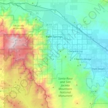
Название: Топографическая карта Palm Springs, высота, рельеф.
Местонахождение: Palm Springs, Riverside County, California, United States (33.61242 -116.71209 33.93198 -116.44280)
Средняя высота: 859 м
Минимальная высота: 41 м
Максимальная высота: 3 277 м
Сделать пожертвование
Другие топографические карты
Нажмите на карту, чтобы просмотреть ее топографию, ее высоту и ее рельеф.
Colorado River
United States > California > Riverside County
The entire eastern boundary of the Colorado River Basin runs along the North American Continental Divide and is defined largely by the Rocky Mountains and the Rio Grande Basin. The Wind River Range in Wyoming marks the northern extent of the basin, and is separated from the Colorado Rockies by the endorheic…
Средняя высота: 93 м
Idyllwild-Pine Cove
United States > California > Riverside County
"Mile-high Idyllwild" is a mountain resort about one-mile (1,600 m) in altitude. Idyllwild is flanked by two large rock formations, Tahquitz Peak and Suicide Rock (also known as Lily Rock), which are famous in Southern California rock-climbing circles. It offers no skiing, so "the Hill" has been minimally…
Средняя высота: 1 746 м
Сделать пожертвование