
Спасибо за поддержку этого сайта ❤️
Сделать пожертвование
Сделать пожертвование
Топографическая карта Nedumpana
Нажмите на карту, чтобы отобразить высоту.
Спасибо за поддержку этого сайта ❤️
Сделать пожертвование
Сделать пожертвование
Nedumpana
Nedumpana is a countryside in Kollam district featuring a typical kerala village consisting paddy fields, wetlands, river channels and highlands. The area can be categorised into Ida Nadu (Mid land or plains) with an average elevation of 108 meter above mean sea level. Laterite soil and Alluvial Soil constitutes the major soil types. Major rainy season is the South West Monsoon, which bring about 130cm of rain. Out of the total area , 6276 acres of land is culturable.
Спасибо за поддержку этого сайта ❤️
Сделать пожертвование
Сделать пожертвование
Об этой карте
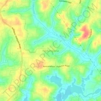
Название: Топографическая карта Nedumpana, высота, рельеф.
Местонахождение: Nedumpana, Kollam, Kerala, 691580, India (8.88875 76.67450 8.92875 76.71450)
Средняя высота: 26 м
Минимальная высота: 1 м
Максимальная высота: 60 м
Спасибо за поддержку этого сайта ❤️
Сделать пожертвование
Сделать пожертвование