
Сделать пожертвование
Топографическая карта Kala Point
Нажмите на карту, чтобы отобразить высоту.
Сделать пожертвование
Об этой карте
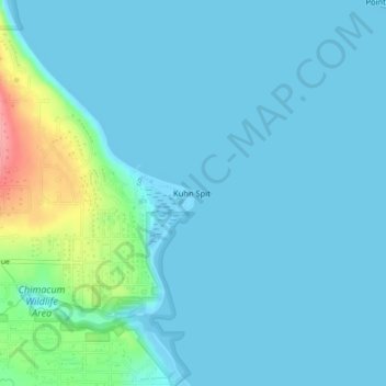
Название: Топографическая карта Kala Point, высота, рельеф.
Местонахождение: Kala Point, Jefferson County, Washington, 98339, United States (48.05775 -122.76655 48.05785 -122.76645)
Средняя высота: 14 м
Минимальная высота: -3 м
Максимальная высота: 100 м
Сделать пожертвование
Другие топографические карты
Нажмите на карту, чтобы просмотреть ее топографию, ее высоту и ее рельеф.
Hoh River
United States > Washington > Jefferson County
The Hoh River Trail, managed by the National Park Service, begins at the national park's Hoh Rain Forest Visitor Center at the end of the Upper Hoh Road. The trail follows the Hoh River east into the heart of the park. After 17.5 mi (28.2 km) it reaches Glacier Meadows near Mount Olympus's Blue Glacier. The…
Средняя высота: 534 м
Сделать пожертвование
Сделать пожертвование
Fort Townsend Historical State Park
United States > Washington > Jefferson County
Средняя высота: 57 м
Сделать пожертвование
Hoh River
United States > Washington > Jefferson County
The Hoh River Trail, managed by the National Park Service, begins at the national park's Hoh Rain Forest Visitor Center at the end of the Upper Hoh Road. The trail follows the Hoh River east into the heart of the park. After 17.5 mi (28.2 km) it reaches Glacier Meadows near Mount Olympus's Blue Glacier. The…
Средняя высота: 531 м
Сделать пожертвование