
Сделать пожертвование
Топографическая карта Fuenlabrada
Нажмите на карту, чтобы отобразить высоту.
Сделать пожертвование
Fuenlabrada
The founding of the village of Fuenlabrada has been tentatively traced to the late 14th century, populated by the dwellers of the nearby settlements of Loranca, Albas and Fregacedos, which had been simultaneously depopulated. The first mention of Fuenlabrada, which by the early 16th century was part of the Land of Madrid, was recorded later in the century, during the reign of Philip II, in the so-called Topographic Relations of Philip II. The village suffered the loss of a quarter of the population in the second half of the 18th century.
Сделать пожертвование
Об этой карте
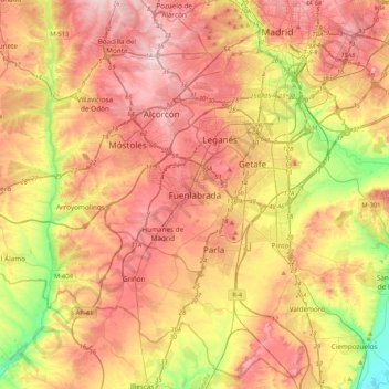
Название: Топографическая карта Fuenlabrada, высота, рельеф.
Местонахождение: Fuenlabrada, Área metropolitana de Madrid y Corredor del Henares, Community of Madrid, 28944, Spain (40.12248 -3.95234 40.44248 -3.63234)
Средняя высота: 630 м
Минимальная высота: 495 м
Максимальная высота: 741 м
Сделать пожертвование