
Сделать пожертвование
Топографическая карта Wichita
Нажмите на карту, чтобы отобразить высоту.
Сделать пожертвование
Wichita
Wichita features a predominantly flat and gently rolling landscape characteristic of the Great Plains region. The city sits at an elevation of approximately 1,300 feet above sea level and is crisscrossed by several small rivers, including the Arkansas River, which flows through the city, providing a slight variation in terrain. The surrounding area consists of expansive agricultural fields, grasslands, and patches of wooded areas, with the Flint Hills to the east offering a more rugged terrain marked by rolling hills and tallgrass prairies. Overall, the topography of Wichita and its vicinity reflects the broader characteristics of the Great Plains, with a mix of open spaces and gentle undulations that create a scenic backdrop for both urban and rural life.
Сделать пожертвование
Об этой карте
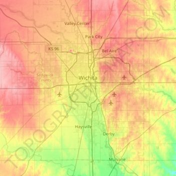
Название: Топографическая карта Wichita, высота, рельеф.
Местонахождение: Wichita, Sedgwick County, Kansas, United States (37.48902 -97.73435 37.84020 -97.15300)
Средняя высота: 408 м
Минимальная высота: 355 м
Максимальная высота: 459 м
Сделать пожертвование
Другие топографические карты
Нажмите на карту, чтобы просмотреть ее топографию, ее высоту и ее рельеф.