
Топографическая карта DeBordieu Colony
Интерактивная карта
Нажмите на карту, чтобы отобразить высоту.
Об этой карте
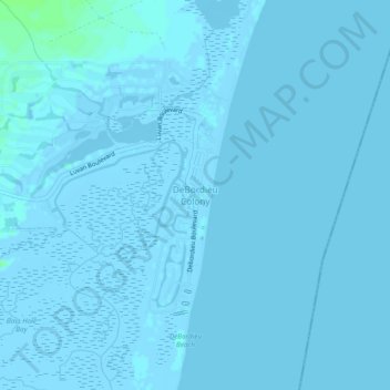
Название: Топографическая карта DeBordieu Colony, высота, рельеф.
Местонахождение: DeBordieu Colony, Georgetown County, South Carolina, United States (33.34906 -79.17171 33.38906 -79.13171)
Средняя высота: 0 м
Минимальная высота: -6 м
Максимальная высота: 7 м
Другие топографические карты
Нажмите на карту, чтобы просмотреть ее топографию, ее высоту и ее рельеф.
Pawleys Island
United States > South Carolina > Georgetown County
Pawleys Island, Georgetown County, South Carolina, United States
Средняя высота: 1 м
Murrells Inlet
United States > South Carolina > Georgetown County
Murrells Inlet, Georgetown County, South Carolina, United States
Средняя высота: 2 м
Huntington Beach State Park
United States > South Carolina > Georgetown County > Murrells Inlet
Huntington Beach State Park, Murrells Inlet, Georgetown County, South Carolina, United States
Средняя высота: 2 м
Andrews
United States > South Carolina > Georgetown County
Andrews, Georgetown County, South Carolina, United States
Средняя высота: 8 м
Waverly Mills
United States > South Carolina > Georgetown County
Waverly Mills, Georgetown County, South Carolina, 29585, United States
Средняя высота: 3 м
Hopewell
United States > South Carolina > Georgetown County
Hopewell, Georgetown County, South Carolina, United States
Средняя высота: 15 м
North Litchfield Beach
United States > South Carolina > Georgetown County
North Litchfield Beach, Georgetown County, South Carolina, United States
Средняя высота: 2 м
Brookgreen Gardens
United States > South Carolina > Georgetown County > Murrells Inlet
Brookgreen Gardens, Murrells Inlet, Georgetown County, South Carolina, United States
Средняя высота: 4 м
Lodge Hall
United States > South Carolina > Georgetown County
Lodge Hall, Georgetown County, South Carolina, United States
Средняя высота: 8 м
North Santee
United States > South Carolina > Georgetown County
North Santee, Georgetown County, South Carolina, United States
Средняя высота: 6 м
Georgetown
United States > South Carolina > Georgetown County > Georgetown
Georgetown, Georgetown County, South Carolina, United States
Средняя высота: 2 м
White Hall Estates
United States > South Carolina > Georgetown County
White Hall Estates, Georgetown County, South Carolina, United States
Средняя высота: 3 м
Georgetown
United States > South Carolina > Georgetown County > Georgetown
Georgetown, Georgetown County, South Carolina, 29440, United States
Средняя высота: 3 м
Dunbar Landing
United States > South Carolina > Georgetown County > Dunbar Landing
Dunbar Landing, Georgetown County, South Carolina, United States
Средняя высота: 6 м
Country Club Estates
United States > South Carolina > Georgetown County > Georgetown > Country Club Estates
Country Club Estates, Georgetown, Georgetown County, South Carolina, 29440, United States
Средняя высота: 3 м
The Reserve
United States > South Carolina > Georgetown County
The Reserve, Georgetown County, South Carolina, 29585, United States
Средняя высота: 3 м
Litchfield by the Sea
United States > South Carolina > Georgetown County > North Litchfield Beach
Litchfield by the Sea, North Litchfield Beach, Georgetown County, South Carolina, 29585, United States
Средняя высота: 2 м
Holly Hill
United States > South Carolina > Georgetown County
Holly Hill, Georgetown County, South Carolina, 29585, United States
Средняя высота: 5 м