
Сделать пожертвование
Топографическая карта Stone Mountain
Нажмите на карту, чтобы отобразить высоту.
Сделать пожертвование
Stone Mountain
The park is owned by the state of Georgia and is currently managed by Herschend Family Entertainment. At its summit, the elevation is 1,686 feet (514 m) above sea level and 825 feet (251 m) above the surrounding area. Stone Mountain is well known for not only its geology, but also the enormous rock relief on its north face, the largest bas-relief artwork in the world. The carving, completed in 1972, depicts three Confederate leaders, Jefferson Davis, Robert E. Lee, and Stonewall Jackson.
Сделать пожертвование
Об этой карте
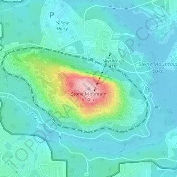
Название: Топографическая карта Stone Mountain, высота, рельеф.
Местонахождение: Stone Mountain, DeKalb County, Georgia, 30087, United States (33.80617 -84.14580 33.80627 -84.14570)
Средняя высота: 299 м
Минимальная высота: 254 м
Максимальная высота: 513 м
Сделать пожертвование
Другие топографические карты
Нажмите на карту, чтобы просмотреть ее топографию, ее высоту и ее рельеф.
Сделать пожертвование
Сделать пожертвование
Tucker
United States > Georgia > DeKalb County
Tucker, at 1,117 feet (340 m) above sea level, is the highest point of elevation on the railroad line between Atlanta and Richmond, Virginia.
Средняя высота: 307 м
Сделать пожертвование
Tucker
United States > Georgia > DeKalb County
Tucker, at 1,117 feet (340 m) feet above sea level, is the highest point of elevation on the railroad line between Atlanta and Richmond, Virginia.
Средняя высота: 307 м
Сделать пожертвование
Tucker
United States > Georgia > DeKalb County > Tucker
Tucker, at 1,117 feet (340 m) feet above sea level, is the highest point of elevation on the railroad line between Atlanta and Richmond, Virginia.
Средняя высота: 317 м
Сделать пожертвование
Сделать пожертвование