
Топографическая карта Behchokǫ̀
Интерактивная карта
Нажмите на карту, чтобы отобразить высоту.
Об этой карте
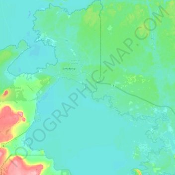
Название: Топографическая карта Behchokǫ̀, высота, рельеф.
Местонахождение: Behchokǫ̀, North Slave Region, Northwest Territories, X0E 0Y0, Canada (62.65853 -116.21803 62.87428 -115.88603)
Средняя высота: 169 м
Минимальная высота: 152 м
Максимальная высота: 257 м
As the community grew alongside increased services such as a mission-run hospital and church, the government viewed the topography of Fort Rae as unsuitable for expansion. In the 1950s there was concern about runoff from animal and human wastes contaminating sources of drinking water, and the government proposed constructing a new settlement on more favourable terrain. The community became known as Edzo and was located on the west side of the Frank Channel opposite Fort Rae a 24 km (15 mi) drive away. Most of the Dene families refused to move from their community so that Rae (62°49′43″N 116°03′08″W / 62.82861°N 116.05222°W / 62.82861; -116.05222 (Rae)) and Edzo (62°46′30″N 116°02′26″W / 62.77500°N 116.04056°W / 62.77500; -116.04056 (Edzo)) (Rae-Edzo) became two separate communities although administered together.
Другие топографические карты
Нажмите на карту, чтобы просмотреть ее топографию, ее высоту и ее рельеф.
Lac de Gras
Canada > Northwest Territories > North Slave Region
Lac de Gras, North Slave Region, Northwest Territories, Canada
Средняя высота: 445 м
Yellowknife
Canada > Northwest Territories > North Slave Region
Yellowknife, North Slave Region, Northwest Territories, Canada
Средняя высота: 185 м