
Топографическая карта Priddis
Интерактивная карта
Нажмите на карту, чтобы отобразить высоту.
Об этой карте
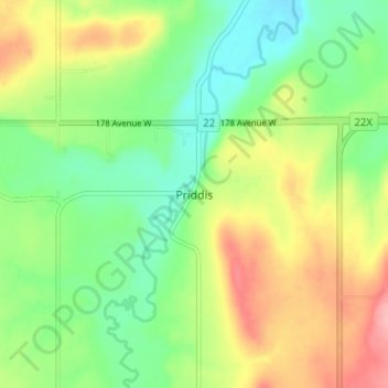
Название: Топографическая карта Priddis, высота, рельеф.
Местонахождение: Priddis, Foothills County, Alberta, Canada (50.86479 -114.34574 50.90479 -114.30574)
Средняя высота: 1 193 м
Минимальная высота: 1 146 м
Максимальная высота: 1 262 м
Priddis is a hamlet in Alberta, Canada within Foothills County. It is located in the foothills of the Canadian Rockies at an elevation of 1,160 metres (3,810 ft). The hamlet is located southwest of the intersection of the Cowboy Trail (Highway 22) and Highway 22X, approximately 10 kilometres (6.2 mi) west of Calgary's city limits.
Другие топографические карты
Нажмите на карту, чтобы просмотреть ее топографию, ее высоту и ее рельеф.
Brown-Lowery Provincial Park
Canada > Alberta > Foothills County
Brown-Lowery Provincial Park, Foothills County, Alberta, Canada
Средняя высота: 1 353 м
Aldersyde
Canada > Alberta > Foothills County
Aldersyde, Foothills County, Alberta, T0L 1T0, Canada
Средняя высота: 1 046 м
Sheep River
Canada > Alberta > Foothills County
Sheep River, Foothills County, Alberta, Canada
Средняя высота: 1 426 м
Millarville
Canada > Alberta > Foothills County
Millarville, Foothills County, Alberta, T0L 1K0, Canada
Средняя высота: 1 220 м
Sheep River
Canada > Alberta > Foothills County
Sheep River, Foothills County, Alberta, T0L 2O0, Canada
Средняя высота: 1 358 м
Highwood River
Canada > Alberta > Foothills County > Village of Longview
Highwood River, Village of Longview, Foothills County, Alberta, T0L 1H0, Canada
Средняя высота: 1 232 м
De Winton
Canada > Alberta > Foothills County
De Winton, Foothills County, Alberta, T2V 3Z4, Canada
Средняя высота: 1 104 м
Cayley
Canada > Alberta > Foothills County
Cayley, Foothills County, Alberta, Canada
Средняя высота: 1 070 м
Hartell
Canada > Alberta > Foothills County
Hartell, Foothills County, Alberta, Canada
Средняя высота: 1 266 м